Welcome!

Benvenuti in queste pagine dedicate a scienza, storia ed arte. Amelia Carolina Sparavigna, Torino

Friday, January 9, 2015

Castlerigg stone circle

The stone circle at Castleriggis situated near Keswick in Cumbria. One of around 1,300 stone circles in the British Isles and Brittany, it was constructed as a part of a megalithic tradition that lasted from 3,300 to 900 BCE, during the Late Neolithic and Early Bronze Ages. (Wikipedia). It is in a location northern of the Hardknott Roman Fort.To have a detailed discussion of the alignment of the stones at Castlerigg, please visit this site
http://www.ancient-wisdom.co.uk/englandcastlerigg.htm

In the following images, using SunCalc, we cans ee how the sun is moving above this stone circle.


Summer solstice


Winter solstice

Here the map showing position of the stone circle and of the roman fort.


SunCalc at the Hardknott Roman Fort

As told by its owner (Vladimir Agafonkin), SunCalc is an app that shows sun movement and sunlight phases during the given day at the given location, where we can see sun positions at sunrise, specified time and sunset. A thin orange curve is the current sun trajectory, and the yellow area around is the variation of sun trajectories during the year. The closer a point is to the center, the higher is the sun above the horizon.


Here an example: SunCalc at the hardkontt Roman Fort


Summer solstice


Winter solstice

More at:
http://www.foxnews.com/science/2015/01/07/let-in-light-ancient-roman-fort-designed-for-celestial-show/

Suncalc and ancient Sun

In a recent paper, entitled "Was Lepenski Vir an ancient Sun or Pleiades observatory?", the authors Vladan Pankovic, Milan Mrdjen and Miodrag Krmar, have discussed the hypotesis of the mesolithic village Lepenski Vir (9500 -- 5500 BC) as an ancient (one of the oldest) Sun observatory. The authors had been so kind to follow a method I suggested of using "freely available software" for the local Sun radiation direction simulation. I used sollumis.com , they used the suncalc.net software.
Here an example of suncalc software.


Wednesday, December 31, 2014

Atlantis Orichalcum


Ripescato nel mare di Gela il tesoro di Atlantide
 
La Soprintendenza del Mare ha riportato alla luce 39 lingotti di Oricalco: risalgono a 2600 anni fa. Per Platone era il misterioso metallo di Atlantide.

Un tesoro è stato ripescato nel litorale di contrada “Bulala” nel mare di Gela, in una zona che in passato ha restituito i resti di ben tre navi arcaiche. All’interno di un relitto databile alla prima metà del VI secolo a. C., 39 lingotti di un materiale nobile, l’Oricalco, simile al moderno ottone, noto nell’antichità come metallo prezioso, tanto da essere considerato al terzo posto per valore commerciale, dopo oro e argento.

https://web.archive.org/web/20161020063759/http://www.globalist.it/Detail_News_Display?ID=67282&typeb=0&Ripescato-nel-mare-di-Gela-il-tesoro-di-Atlantide


Oricalco, museo di Gela
Immagine Cortesia di Emanuele Riela - Opera propria


Wednesday, December 24, 2014

Artù a Mediobogdum (Hardknott Roman Fort)

"Il forte è il luogo in cui un Artù bambino trascorre gli anni dell'infanzia, vegliato e istruito da un giovane Merlino"
http://it.wikipedia.org/wiki/Mediobogdum

Friday, December 19, 2014

Solstices at the Hardknott Roman Fort

A roman fort in Britannia, a specific orientation to solstices


More at SSRN


Solstices at the Hardknott Roman Fort

Amelia Carolina Sparavigna

Department of Applied Science and Technology, Politecnico di Torino


Abstract

From the most ancient times, the Roman military camps were planned according to a certain ideal pattern that was also applied to the coloniae, the outposts established in the territories conquered by Rome. The planning of castra and colonies was based on a chessboard of parallel streets, the main of them being the Decumanus. Probably, some Decumani were oriented to confer a symbolic meaning to the place too. Here we discuss the distinctive layout of a castrum in the Roman Britannia, the Hardknott Fort, and its orientation to the solstices.

Keywords: Archeoastronomy, Solar Orientation, Solstices, Urban Planning, Satellite Images, Google Earth.

Wednesday, November 5, 2014

Carbon Dioxide Concentration and Emissions in Atmosphere: Trends and Recurrence Plots

The increase of carbon dioxide concentration in atmosphere, due to anthropogenic emissions, is almost generally considered as responsible of global climate changes. We show some data of CO2 concentration and its emission in atmosphere, using the recurrence plots to enhance the visualization of their trends.  See more at: http://www.ijsciences.com/pub/article/582#sthash.L4dBnzsh.dpuf

Data of CO2 concentration in atmosphere, from [1]. The range is from January 1958 to October 2014. In the image we see the recurrence plot. The global annual mean concentration of CO2 in the atmosphere is currently rising at a rate of approximately 2 ppm/year and accelerating [1]. This acceleration is shown by the recurrence plot, where colours are narrowing towards the diagonal line.
[1] Tans, P. & Keeling R. (2014). Trends in atmospheric carbon dioxide, Oceanic & Atmospheric Administration (NOAA). At www.esrl.noaa.gov/ gmd/ ccgg/ trends/


About 1970, the oil production and import of US had a sharp peak (data from Ref.12). Note how the corresponding recurrence plot evidences this peak.
[12] Vv.Aa. (2014). U.S. Energy Information Administration (EIA), at www.eia.gov/petroleum/

 See more at: http://www.ijsciences.com/pub/article/582#sthash.L4dBnzsh.dpuf

Wednesday, August 13, 2014

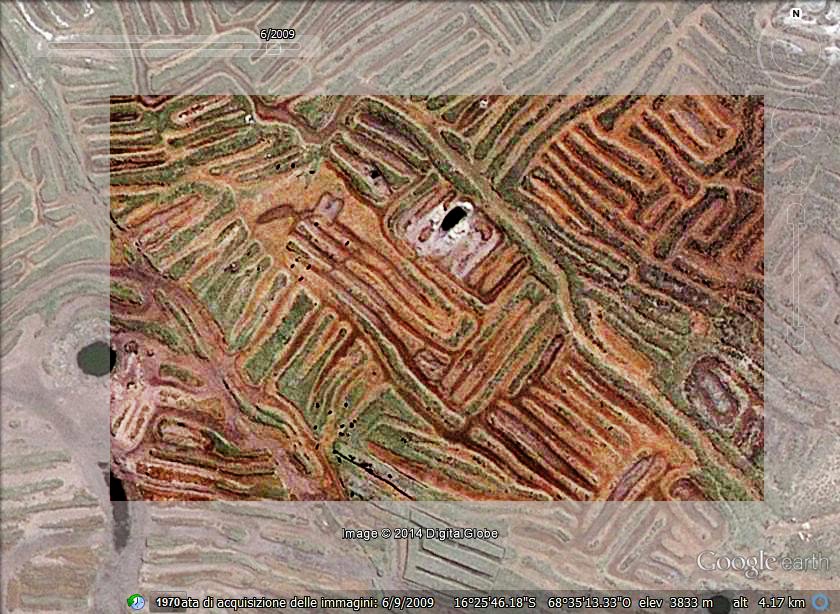
Geoglyphs of Titicaca - 2 - A snake


The image, obtained from Google Maps, shows the network of earthworks separated by canals - near the Titicaca Lake. This is an ancient agricultural technique used by Andean people starting from the first millennium BC. 


More on Titicaca

arXiv:1009.4602 [pdf] Geoglyphs of Titicaca as an ancient example of graphic design,
Amelia Carolina Sparavigna
arXiv:1009.2231 [pdf] Symbolic landforms created by ancient earthworks near Lake Titicaca, Amelia Carolina Sparavigna

A.C. Sparavigna (2012) 
Image Processing for the Enhancement of Satellite Imagery. In: Image Processing: Methods, Applications and Challenges / Vítor Hugo Carvalho. Nova Science Publishers, Inc. (USA), pp. 149-161. ISBN 9781620818442 

A.C. Sparavigna, R. Marazzato (2011)
Using Geographic Information Systems to Increment the Knowledge of Cultural Landscapes. In: Smart Tech & Smart Innovation, La strada per costruire il futuro, Torino, 15-17 Novembre 2011. 
[img] [img]
A.C. Sparavigna (2010)
The geoglyphs of Titicaca. In: ARCHAEOGATE n. 13-10-. - ISSN 1973-2953 
[img] [img]

Tuesday, August 12, 2014

Geoglyphs of Titicaca - 1


Earthworks near Titicaca Lake create "geoglyphs"
These earthworks are known as "raised fields" and "waru-warus".

The image, obtained from Google Maps, shows the network of earthworks separated by canals - near the Titicaca Lake (Huata, Puno, Peru). This is an ancient agricultural technique used by Andean people starting from the first millennium BC. Note that the structure of the network is created after a careful planning. Each raised field is approximately 10 meters large and more than one hundred long.


More on Titicaca

arXiv:1009.4602 [pdf] Geoglyphs of Titicaca as an ancient example of graphic design,
Amelia Carolina Sparavigna
arXiv:1009.2231 [pdf] Symbolic landforms created by ancient earthworks near Lake Titicaca, Amelia Carolina Sparavigna

A.C. Sparavigna (2012) 
Image Processing for the Enhancement of Satellite Imagery. In: Image Processing: Methods, Applications and Challenges / Vítor Hugo Carvalho. Nova Science Publishers, Inc. (USA), pp. 149-161. ISBN 9781620818442 

A.C. Sparavigna, R. Marazzato (2011)
Using Geographic Information Systems to Increment the Knowledge of Cultural Landscapes. In: Smart Tech & Smart Innovation, La strada per costruire il futuro, Torino, 15-17 Novembre 2011. 
[img] [img]
A.C. Sparavigna (2010)
The geoglyphs of Titicaca. In: ARCHAEOGATE n. 13-10-. - ISSN 1973-2953 
[img] [img]