Here the news of the day!Neutrinos are faster than light!
http://www.guardian.co.uk/science/2011/sep/23/faster-light-neutrinos
"Scientists at the Opera (Oscillation Project with Emulsion-tRacking Apparatus) experiment in Gran Sasso, Italy, found that beams of neutrinos sent to its detectors from Cern, 730km away in Geneva, arrived earlier than they should have."
Friday, September 23, 2011
Thursday, September 22, 2011
Coherers as “energy catalyzers”
Coherers as “energy catalyzers”
Amelia Carolina Sparavigna
Dipartimento di Fisica,
Politecnico di Torino, Torino, Italy
------------
On Wednesday September 21, 2011, from the news of RAI, the Italian broadcaster, I learned that a new device for energy production was on the way for industrial developments. I had not immediately realized the features of this device, but I memorized the fact that it was based on water, nickel powders and current, that I saw sparkling in the video clip. After searching on the Web, I found that the announced device was the energy catalyzer, E-Cat, under patent request by its inventor, Andrea Rossi. The development of prototypes was due to the work of Rossi and Sergio Focardi, University of Bologna. It seems that they have announced a device able of producing more than 10 kilowatts of heat power, while only consuming a fraction of that. "On January 14, 2011, they gave the Worlds' first public demonstration of a nickel-hydrogen fusion reactor capable of producing a few kilowatts of thermal energy. At its peak, it is capable of generating 15,000 watts with just 400 watts input required. In a following test the same output was achieved but with only 80 watts of continual input" [1]. The item is also reporting that the inventor prefers to invoke a catalyzer process, not to a cold fusion. There are so many Web pages on the E-Cat, that it is impossible to list them, but an exhaustive one is the corresponding Wikipedia item [2]. It is there that we can find the reference to the patent [3], which is about a "method and apparatus for carrying out a highly efficient exothermal reaction between nickel atoms and hydrogen atoms, in a tube, preferably, though not exclusively made of a metal, filled by a nickel powder and heated to a high temperature preferably, though not necessarily, from 150 to 5000°C, by injecting hydrogen into said metal tube said nickel powder being pressurized, preferably, though not necessarily, to a pressure from 2 to 20 bars ".
The confidence on this device does not allow its discussion. And in fact, the aim of my paper is not a discussion on E-Cat, but on what the poor information on it suggested me. Some features of the device attracted my interest: they are the metal powders, the high temperatures and the sparks of electricity. In fact I read recently about all these things together in a old book published in 1904, entitled Element of Physics, by Fernando Sanford, professor at the Stanford University, one of the members of the group of scientists who came there to create the pioneer faculty in 1891. In [4], I discussed the experiments of Sanford on the electric photography and the fact that, several years after in 1939, the fringes around the electrically photographed objects had been rediscovered by Semyon Kirlian. Of course the book written by Sanford is quite old, but, in my opinion, it has to be appreciated due to the fact that it is based on the description of experiments. The book is then quite interesting from the point of view of experimental physics and for its history. A chapter is devoted to electric radiation and electric waves. Let us remember that Fernando Sanford was talking of experiments, which, at his times were revolutionizing physics and technology. Reading the book we learn that a new device was used in laboratories, the Coherer (see Fig.1). Let me report the Laboratory Exercise 119 of the book
"Take a glass tube of about a centimeter bore and six or eight centimeters long, fit the ends with corks through which copper wires can be passed, and fill the tube between the corks with brass or iron filings. Thrust copper wires through the corks and into the iron filings until their ends are one or two centimeters apart. Connect these wires in circuit with one or more voltaic cells and a tolerably sensitive galvanometer. The resistance of the filings to the passage of a current should be so great that the galvanometer is slightly, if at all, deflected. Bring an electric machine near, and pass sparks from one discharging knob into one of the wires which enter the tube. The resistance should fall so that the galvanometer is deflected through nearly 90°. This instrument is called a Coherer. The passage of the electric discharge into the small metallic particles in the tube apparently causes them to cling together so that they make better electric contact than before. After your coherer has become sensitive enough to allow the passage of a suitable current, increase its resistance again by tapping gently on the glass and causing the particles to separate. Then move the electric machine to a distance of a few feet from the coherer and turn the handle and cause sparks to pass between the discharging knobs of the machine. If your coherer has been properly adjusted, the galvanometer will be deflected again, showing that the resistance of the coherer has been again diminished. By a little care in the adjustment, and by using a sensitive galvanometer, the coherer will respond to a spark at a distance of several yards. ... The Coherer described above is similar to the receiver used in "wireless telegraphy." The Coherer is connected between a battery and a telegraph sounder, and is attached to a long wire or other conductor suspended at some height. A similar conductor is suspended at the sending station, and is connected with the spark gap of the electric machine or induction coil. The oscillations in the receiving conductor are accordingly partly due to resonance, and they are sufficient to lower the resistance of the coherer so that a signal can be made through it. An automatic tapper jars the particles apart, so that the signal is momentary unless the instrument is sensitized by another spark. "

The device described by Sanford is a radio signal detector used in the receivers of wireless telegraphy at the beginning of the twentieth century. The coherer was invented, around 1890, by Édouard Branly [5]. As described by Sanford, it consisted of a tube or capsule containing two electrodes spaced a small distance apart, with metal filings in the space between them. To have the Branly effect, it is necessary a thin resistive layer between the grains, to have an initial high resistance. The effect is not observed with noble metal grains, cleaned from any surface contaminant. The coherer works because the metal particles cling together, that is cohere after being subjected to the radio frequency electricity. This provokes a reduction in the coherer's electrical resistance, which is persistent after the radio signal. To receive another signal, the device needs a de-coherer mechanism, able to tap the coherer, mechanically disturbing the particles and resetting them to the high resistance state. As Wikipedia [5] is telling "Coherence of particles by radio waves is an obscure phenomenon that is not well understood even today", but several recent experiments with metal particles seem to confirm that particles cohere by a micro-weld phenomenon, caused by radio frequency electricity fluxing across the small contact area between particles. This phenomenon is probably involving a tunnelling of charge carriers across an imperfect junction between conductors, as deeply discussed in Ref.6. In fact, in this reference the author is proposing to relate the Branly effect to the induced tunnelling effect first described by François Bardou and Dominique Boosé, asserting then that the effect is mainly governed by an electrical tunnel effect [7].
In the work published in 2001 [7], Bardou and Boosé theoretically proposed that the tunnelling probability of a particle through a potential barrier could be enhanced by striking the particle when the centroid of its wave packet is reflecting on the barrier. This is applied to Branly effect as discussed in [6] in the following way. “In a granular metallic medium microscopic grains are electrically isolated one from the other by a metal oxide nanometric layer ... When a voltage is applied to the medium, electrons are accelerated and they do reflect on the potential barriers. At the time of the reflection, these electrons can be kicked forward or backward by the short electromagnetic pulses present in the external electromagnetic field. … The enhanced transmission induced by the momentum transfer produces an increased electrical current, that for some events become large enough to permit a local heating in the metal grains thanks to the Joule effect. Eventually a welding of the grains can occur and when a percolation path has formed the electrical resistance of the medium drops down going from an exponential dependence on the applied voltage to a linear one”. Reference 6 is also reporting that Auerbach demonstrated in 1898 that a coherer could be made conducting by an acoustic excitation in the audible range of the spectrum. According to [6], this means that acoustical wave, by giving vibrations to tunnel barriers between the metallic grains, could be responsible of an induced tunnelling.
Let us also consider the recent experiments with particle coherers by Falcon et al. [8]. They reported on observations of the electrical transport within a chain of metallic beads, which were slightly oxidised. As the applied current is increased, a transition from an insulating to a conductive state is observed. The authors are proposing that the transition comes from an electro-thermal coupling, at the micro-contacts between each bead. Due to these contacts, the current flows through them, generating a high local heating. This heating increases the local contact areas, enhancing the conduction. This current-induced temperature rise, up to 1050°C, results in the micro-soldering of the contact points, even for low voltages.
If we define an “energy catalyzer” as a device able to produce change in, or transform energy, the coherer acts in such a manner, where the catalyst is an electromagnetic pulse. Let us hope that as soon as possible, an open report on E-Cat is published, in order to understand the role of hydrogen in it. In this device, is any tunnelling present? Is it there a tunnelling able to give a fusion of nickel and hydrogen to have copper in a proton capture as told in [9]? Is there any kicking mechanism? What we find in [9] is that the paper is just reporting the results “obtained with a process and apparatus not described here (in [9]) in detail and protected by patent in 90 countries, consisting of a system whose heat output is up to hundred times the electric energy input. As a consequence, the principle of the conservation of energy ensures that processes involving other energy forms are occurring in our apparatus”. And in the conservation of energy we trust.
References
1. http://peswiki.com/index.php/Directory:Andrea_A._Rossi_Cold_Fusion_Generator
2. http://en.wikipedia.org/wiki/Energy_Catalyzer
3. http://www.wipo.int/pctdb/en/wo.jsp?IA=IT2008000532&DISPLAY=DESC
4. A.C. Sparavigna, Fernando Sanford and the "Kirlian effect", arXiv:1105.1266v1 [physics.pop-ph], http://arxiv.org/ftp/arxiv/papers/1105/1105.1266.pdf
5. http://en.wikipedia.org/wiki/Coherer
6. C. Hirlimann, Understanding the Branly effect, arXiv:cond-mat/0703495v1 [cond-mat.mtrl-sci], http://arxiv.org/ftp/cond-mat/papers/0703/0703495.pdf
7. D. Boosé and F. Bardou, A quantum evaporation effect, Europhys. Lett., 53, 1-7 (2001).
8. E. Falcon, B. Castaing, and M. Creyssels, Nonlinear electrical conductivity in a 1D granular medium, The European Physical Journal B, 38, 475-483 (2004)
9. S. Focardi and A. Rossi, A new energy source from nuclear fusion, http://www.lenr-canr.org/acrobat/FocardiSanewenergy.pdf
Amelia Carolina Sparavigna
Dipartimento di Fisica,
Politecnico di Torino, Torino, Italy
Abstract: A device defined as an “energy catalyzer”, able to give thermal energy at the expense of electric energy, has aroused a great popular interest. In fact, the confidence on this device does not allow its discussion. Some known features are intriguing, which can therefore become the starting point for a discussion on old coherers and the Branly effect. We could define the coherers as a sort of “energy catalyzers”.
------------
On Wednesday September 21, 2011, from the news of RAI, the Italian broadcaster, I learned that a new device for energy production was on the way for industrial developments. I had not immediately realized the features of this device, but I memorized the fact that it was based on water, nickel powders and current, that I saw sparkling in the video clip. After searching on the Web, I found that the announced device was the energy catalyzer, E-Cat, under patent request by its inventor, Andrea Rossi. The development of prototypes was due to the work of Rossi and Sergio Focardi, University of Bologna. It seems that they have announced a device able of producing more than 10 kilowatts of heat power, while only consuming a fraction of that. "On January 14, 2011, they gave the Worlds' first public demonstration of a nickel-hydrogen fusion reactor capable of producing a few kilowatts of thermal energy. At its peak, it is capable of generating 15,000 watts with just 400 watts input required. In a following test the same output was achieved but with only 80 watts of continual input" [1]. The item is also reporting that the inventor prefers to invoke a catalyzer process, not to a cold fusion. There are so many Web pages on the E-Cat, that it is impossible to list them, but an exhaustive one is the corresponding Wikipedia item [2]. It is there that we can find the reference to the patent [3], which is about a "method and apparatus for carrying out a highly efficient exothermal reaction between nickel atoms and hydrogen atoms, in a tube, preferably, though not exclusively made of a metal, filled by a nickel powder and heated to a high temperature preferably, though not necessarily, from 150 to 5000°C, by injecting hydrogen into said metal tube said nickel powder being pressurized, preferably, though not necessarily, to a pressure from 2 to 20 bars ".
The confidence on this device does not allow its discussion. And in fact, the aim of my paper is not a discussion on E-Cat, but on what the poor information on it suggested me. Some features of the device attracted my interest: they are the metal powders, the high temperatures and the sparks of electricity. In fact I read recently about all these things together in a old book published in 1904, entitled Element of Physics, by Fernando Sanford, professor at the Stanford University, one of the members of the group of scientists who came there to create the pioneer faculty in 1891. In [4], I discussed the experiments of Sanford on the electric photography and the fact that, several years after in 1939, the fringes around the electrically photographed objects had been rediscovered by Semyon Kirlian. Of course the book written by Sanford is quite old, but, in my opinion, it has to be appreciated due to the fact that it is based on the description of experiments. The book is then quite interesting from the point of view of experimental physics and for its history. A chapter is devoted to electric radiation and electric waves. Let us remember that Fernando Sanford was talking of experiments, which, at his times were revolutionizing physics and technology. Reading the book we learn that a new device was used in laboratories, the Coherer (see Fig.1). Let me report the Laboratory Exercise 119 of the book
"Take a glass tube of about a centimeter bore and six or eight centimeters long, fit the ends with corks through which copper wires can be passed, and fill the tube between the corks with brass or iron filings. Thrust copper wires through the corks and into the iron filings until their ends are one or two centimeters apart. Connect these wires in circuit with one or more voltaic cells and a tolerably sensitive galvanometer. The resistance of the filings to the passage of a current should be so great that the galvanometer is slightly, if at all, deflected. Bring an electric machine near, and pass sparks from one discharging knob into one of the wires which enter the tube. The resistance should fall so that the galvanometer is deflected through nearly 90°. This instrument is called a Coherer. The passage of the electric discharge into the small metallic particles in the tube apparently causes them to cling together so that they make better electric contact than before. After your coherer has become sensitive enough to allow the passage of a suitable current, increase its resistance again by tapping gently on the glass and causing the particles to separate. Then move the electric machine to a distance of a few feet from the coherer and turn the handle and cause sparks to pass between the discharging knobs of the machine. If your coherer has been properly adjusted, the galvanometer will be deflected again, showing that the resistance of the coherer has been again diminished. By a little care in the adjustment, and by using a sensitive galvanometer, the coherer will respond to a spark at a distance of several yards. ... The Coherer described above is similar to the receiver used in "wireless telegraphy." The Coherer is connected between a battery and a telegraph sounder, and is attached to a long wire or other conductor suspended at some height. A similar conductor is suspended at the sending station, and is connected with the spark gap of the electric machine or induction coil. The oscillations in the receiving conductor are accordingly partly due to resonance, and they are sufficient to lower the resistance of the coherer so that a signal can be made through it. An automatic tapper jars the particles apart, so that the signal is momentary unless the instrument is sensitized by another spark. "

Fig.1. The Coherer in the book written by F. Sanford.
The device described by Sanford is a radio signal detector used in the receivers of wireless telegraphy at the beginning of the twentieth century. The coherer was invented, around 1890, by Édouard Branly [5]. As described by Sanford, it consisted of a tube or capsule containing two electrodes spaced a small distance apart, with metal filings in the space between them. To have the Branly effect, it is necessary a thin resistive layer between the grains, to have an initial high resistance. The effect is not observed with noble metal grains, cleaned from any surface contaminant. The coherer works because the metal particles cling together, that is cohere after being subjected to the radio frequency electricity. This provokes a reduction in the coherer's electrical resistance, which is persistent after the radio signal. To receive another signal, the device needs a de-coherer mechanism, able to tap the coherer, mechanically disturbing the particles and resetting them to the high resistance state. As Wikipedia [5] is telling "Coherence of particles by radio waves is an obscure phenomenon that is not well understood even today", but several recent experiments with metal particles seem to confirm that particles cohere by a micro-weld phenomenon, caused by radio frequency electricity fluxing across the small contact area between particles. This phenomenon is probably involving a tunnelling of charge carriers across an imperfect junction between conductors, as deeply discussed in Ref.6. In fact, in this reference the author is proposing to relate the Branly effect to the induced tunnelling effect first described by François Bardou and Dominique Boosé, asserting then that the effect is mainly governed by an electrical tunnel effect [7].
In the work published in 2001 [7], Bardou and Boosé theoretically proposed that the tunnelling probability of a particle through a potential barrier could be enhanced by striking the particle when the centroid of its wave packet is reflecting on the barrier. This is applied to Branly effect as discussed in [6] in the following way. “In a granular metallic medium microscopic grains are electrically isolated one from the other by a metal oxide nanometric layer ... When a voltage is applied to the medium, electrons are accelerated and they do reflect on the potential barriers. At the time of the reflection, these electrons can be kicked forward or backward by the short electromagnetic pulses present in the external electromagnetic field. … The enhanced transmission induced by the momentum transfer produces an increased electrical current, that for some events become large enough to permit a local heating in the metal grains thanks to the Joule effect. Eventually a welding of the grains can occur and when a percolation path has formed the electrical resistance of the medium drops down going from an exponential dependence on the applied voltage to a linear one”. Reference 6 is also reporting that Auerbach demonstrated in 1898 that a coherer could be made conducting by an acoustic excitation in the audible range of the spectrum. According to [6], this means that acoustical wave, by giving vibrations to tunnel barriers between the metallic grains, could be responsible of an induced tunnelling.
Let us also consider the recent experiments with particle coherers by Falcon et al. [8]. They reported on observations of the electrical transport within a chain of metallic beads, which were slightly oxidised. As the applied current is increased, a transition from an insulating to a conductive state is observed. The authors are proposing that the transition comes from an electro-thermal coupling, at the micro-contacts between each bead. Due to these contacts, the current flows through them, generating a high local heating. This heating increases the local contact areas, enhancing the conduction. This current-induced temperature rise, up to 1050°C, results in the micro-soldering of the contact points, even for low voltages.
If we define an “energy catalyzer” as a device able to produce change in, or transform energy, the coherer acts in such a manner, where the catalyst is an electromagnetic pulse. Let us hope that as soon as possible, an open report on E-Cat is published, in order to understand the role of hydrogen in it. In this device, is any tunnelling present? Is it there a tunnelling able to give a fusion of nickel and hydrogen to have copper in a proton capture as told in [9]? Is there any kicking mechanism? What we find in [9] is that the paper is just reporting the results “obtained with a process and apparatus not described here (in [9]) in detail and protected by patent in 90 countries, consisting of a system whose heat output is up to hundred times the electric energy input. As a consequence, the principle of the conservation of energy ensures that processes involving other energy forms are occurring in our apparatus”. And in the conservation of energy we trust.
References
1. http://peswiki.com/index.php/Directory:Andrea_A._Rossi_Cold_Fusion_Generator
2. http://en.wikipedia.org/wiki/Energy_Catalyzer
3. http://www.wipo.int/pctdb/en/wo.jsp?IA=IT2008000532&DISPLAY=DESC
4. A.C. Sparavigna, Fernando Sanford and the "Kirlian effect", arXiv:1105.1266v1 [physics.pop-ph], http://arxiv.org/ftp/arxiv/papers/1105/1105.1266.pdf
5. http://en.wikipedia.org/wiki/Coherer
6. C. Hirlimann, Understanding the Branly effect, arXiv:cond-mat/0703495v1 [cond-mat.mtrl-sci], http://arxiv.org/ftp/cond-mat/papers/0703/0703495.pdf
7. D. Boosé and F. Bardou, A quantum evaporation effect, Europhys. Lett., 53, 1-7 (2001).
8. E. Falcon, B. Castaing, and M. Creyssels, Nonlinear electrical conductivity in a 1D granular medium, The European Physical Journal B, 38, 475-483 (2004)
9. S. Focardi and A. Rossi, A new energy source from nuclear fusion, http://www.lenr-canr.org/acrobat/FocardiSanewenergy.pdf
Wednesday, September 7, 2011
Magnetic scan without magnets
Magnetic scans with a tiny magnet, by Michael Schirber
discussion of the paper entitled Near-Zero-Field Nuclear Magnetic Resonance by M. P. Ledbetter, T. Theis, J. W. Blanchard, H. Ring, P. Ganssle, S. Appelt, B. Blümich, A. Pines, and D. Budker
Phys. Rev. Lett. 107, 107601 (Published September 1, 2011)"Nuclear magnetic resonance is a powerful technique for analyzing molecular structure in biology, medicine, and materials science. Conventionally, it calls for huge magnets to align nuclear spins and to detect them with high sensitivity, but recent work has demonstrated that similar analysis can be done without a magnetic field. The problem with this zero-field technique is that it can’t unambiguously identify molecules. Now, in a paper in Physical Review Letters, Micah Ledbetter of the University of California, Berkeley, and his collaborators address this limitation, showing that a very small magnetic field can provide extra signatures for chemical discrimination."
http://physics.aps.org/synopsis-for/10.1103/PhysRevLett.107.107601
Tuesday, August 30, 2011
Concrete in the Great Pyramids
Did the Great Pyramids' builders use concrete?
This is the question we can find in the article by Colin Nickerson on New York Times.
http://www.nytimes.com/2008/04/23/world/africa/23iht-pyramid.1.12259608.html
"It is a theory that gives indigestion to mainstream archaeologists. Namely, that some of the immense blocks of the Great Pyramids of Egypt might have been cast from synthetic material - the world's first concrete - not just carved whole from quarries and lugged into place by armies of toilers. Such an innovation would have saved millions of man-hours of grunting and heaving in construction of the enigmatic edifices on the Giza Plateau."
See also:
Revisiting the construction of pyramids
Wednesday, August 3, 2011
Objeto del antiguo Egipto sería el primer transportador en el mundo
"Un objeto hallado en una tumba egipcia hace más de 100 años sería el primer transportador, función que finalmente se plante tras un largo misterio entre los arqueólogos sobre su utilidad según informa la revista New Scientist."
Connuestroperu Objeto del antiguo Egipto sería el primer transportador en el mundo
Tuesday, August 2, 2011
Toshka Lakes from space
The decreasing level of Toshka Lakes seen from space
Amelia Carolina Sparavigna, Dipartimento di Fisica, Politecnico di Torino
http://arxiv.org/abs/1107.4430
Toshka Lakes are lakes recently formed in the Sahara Desert of Egypt, by the water of the Nile, conveyed from the Nasser Lake through a canal in the Toshka Depression. From space, astronauts noticed the growing of a first lake, the easternmost one, in 1998. Then additional lakes grew in succession due west, the westernmost one between 2000 and 2001. In fact, sources of precious information on Toshka Lakes are the pictures takes by the crews of space missions and the satellite imagery. They show that, from 2006, the lakes started shrinking. A set of recent images displays that the surface of the easternmost lake is strongly reduced.
Toshka Lakes is the name given to the lakes, quite recently formed, in the Sahara Desert of Egypt. These new lakes are endorheic, that is, the water can never flow out this region toward the sea. They are near the Nasser Lake (see the map in Fig.1), the huge lake created by the Aswan High Dam, built in 1964-1968. As Wikipedia is reporting [1], in 1978, Egypt began to build the Sadat Canal, originating from the Lake Nasser and passing through the Wadi Toshka, to allow the water, when it is overflowing a specific level, to be drained off to flood a depression located at the south end of a desert limestone plateau. This is the Toshka Depression. In fact, the Egyptian government decided to undertake a development project of the surrounding region, known as the "New Valley Project". The project intends to extend this waterway till the Kharga oasis.

Fig.1 Toshka Lakes are lakes recently formed in the Sahara Desert of Egypt. They are near the Nasser Lake, the huge lake was created by the Aswan High Dam, built in 1964-1968. The water is flowing in the Sadat Canal, pumped in the Toshka Depression, when it is overflowing a specific level in the Lake Nasser. The image has been adapted from the Google Maps.
It was in late 1990s [1] that the water started flowing in the canal. This waterway, feeding the depression with the water from Nile, was prepared in order to reduce the water losses. This water, in order to flow the Sadat Canal needs a pumping station, which is situated north of Abu Simbel. From space, astronauts noticed the growing of a first lake, the easternmost one, in November 1998 [1]. They saw the other lakes grown in succession westward, the westernmost lake between September 2000 and March 2001. A public source of information on Toshka Lakes is in fact in the pictures taken by the crews of space missions. Starting from 2006, the images show that the lakes started shrinking, because of a reduction of water supply [3]. One of the lakes dried out. As reported in [3], the flooding of the Toshka Depression had created the four wide lakes, with their maximum surface area in 2002, of ca 1,500 km^2 , having about 5 × 10^9 m^3 of water. Some of the water evaporated and some recharges the underlying aquifer [3]. At the beginning of the
flooding, the fauna and flora of Nile invaded the Toshka valley [3], with a resultant very rich population of fishes. But, unfortunately, the water supply reduced. The western-most lake shows a rapidly increasing salinity. As the researches are observing, the zooplankton reacts to the increase of salinity by a striking impoverishment [3]. The life in the lake started to decline. A publication [4] estimated the loss of water from the lakes using remote sensing and GIS, collecting a set of images and processing them to show the aerial extend shrinkage of these lakes from 2002 up to 2007. By means of a spatial analysis of bathymetry in a digital elevation model, the authors found that the loss rate is around 2.5 m/year. They noted that the lakes stored around 25.26 billion cubic meters of water in 2002, but in 2006 the stored water was reduced to 12.57 billion cubic. The authors conclude that the location of these lakes in such hyper-arid zone is
responsible for a high loss rate, mainly caused by the evaporation, because they found the percolation of water through the ground quite limited. They say that “It is strongly recommended that measures must be taken to maximize the benefits of these huge, exceptional water resources before totally lost via evaporation. Additionally, geo-environmental problems are likely to arise from the concentration of salts when the lakes dry up”.
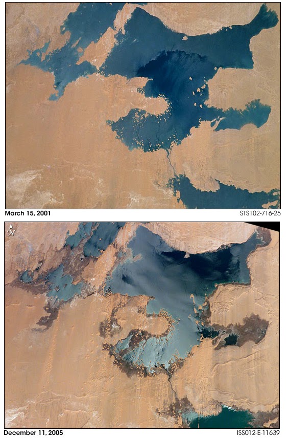
Fig.2 The "NASA Earth Observatory" allows to see the evolution from 2001 to 2005, of the western Toshka Lakes. In the upper image, we have a record of the lakes as soon as they formed. But in 2005, the water level was strongly reduced.
Let us see what happened by means of the NASA satellite imagery. The "NASA Earth Observatory" allow us to see the evolution of the western Toshka Lakes (see Fig.2). In the upper image, we have a figure of the lakes as soon as they formed, 2001. But in 2005, the water level was strongly reduced. In Fig.3, the "NASA Earth Observatory" dated 2005 is compared with an image that we can obtain (on date July 21, 2011) from Google Maps. It is not possible for the author to tell when the Google image had been recorded. But, surely it is more recent, because we see a further reduction of the surfaces of the lakes.

Fig.3 The "NASA Earth Observatory" of the western Toshka Lakes in 2005 (upper panel) is compared with an image from Google Maps (downloaded July 21, 2011). It is not possible for the author to tell when the image of the lower panel had been recorded. But, surely it is more recent. We can see a further reduction of water in the lakes.
Let us note that reference [4] is dated 2007. But what is the current situation of the lakes?
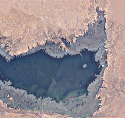
Let us try to answer using NASA images again, and in particular, those of the easternmost Toshka Lake. In 2005, it was as shown in upper panel of Fig.4, as provided by the "Gateway to Astronaut Photography of Earth". The original image has been enhanced and rotated to compare it with that provided the Google Maps, displayed in the lower panel of Fig.4. As told for Fig.3, it is not possible for me to date the Google image; surely after 2005, because comparing the images, we note that the surface of the lake had shrunk.

Fig.4 The easternmost Toshka Lake in 2005, as provided by the "Gateway to Astronaut Photography of Earth", is shown in the upper panel. The original image has been enhanced and rotated to compare it with that provided (downloaded July 21, 2011) by the Google Maps, displayed in the lower panel. Note that, it is not possible for me to date the Google image. I can only tell thta it is surely after 2005, because comparing the images, we note that the surface of the lake had shrunk.
But the "Gateway to Astronaut Photography of Earth" has a set of images of March 31, 2011, quite recent then, that allowed me to create a composite map of the current aspect of the lake. The map is proposed in Fig.5. This map had been rotated and enhanced as discussed in Ref. 5 (the image processing proposed in [5] has interesting applications in archaeology, see [6]). The processed images have so many details that we can use them to see the evolution of the lake. This is proposed in Fig.6, where we see a part of the lake, as it evolved from 2005 to March 31, 2011. In this figure we pass from the image dated 2005, to that of 2011, through that from Google Maps, of unknown date. This part of the easternmost lake was large in 2005, shrinking between 2005 and 2011, and reduced to one half the original in 2011, as it can be seen in Figure 7, where the superposition of the two NASA images, of 2005 and 2011, is proposed. We see the surface of the lake strongly decreased.

Fig.5 A set of images from the "Gateway to Astronaut Photography of Earth" dated, March 31, 2011, allows to create a composite map of the current aspect of the easternmost lake. This map had been rotated and enhanced as discussed in Ref. 5. The processed image has so many details useful for a comparison with the images in Fig.4.

Fig.6. From the image by the "Gateway to Astronaut Photography of Earth" dated 2005 (up-left), to that of March 31, 2011 (down-right), passing through that from Google Maps (up-right/down-left). The two images labelled with a question mark, are the same. The question mark means that the year when it was recorded is unknown to the author. We have the evolution of a part of the easternmost lake that was large in 2005 shrinking between 2005 and 2011, and reduced to one half the original part in 2011. The surface of the lake has dramatically decreased.
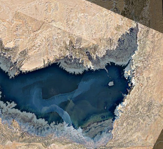
Fig.7. Superposition of the two NASA images, of 2005 and 2011, of Fig.6, proposed to help the reader in the comparison.
Let me continue with a little bit of history. Egypt had already lived a similar situation, but on a longer period and more than two thousand years ago. In Egypt there are several lakes; one is the Lake Moeris, an ancient saltwater lake in the northwest of the Faiyum Oasis. During the prehistory, the lake had freshwaters due to the high flood of Nile. From the XII Dynasty, in 2300 BC, the natural waterway from the river to the lake was widened and deepened to make a canal which is now known as the Bahr Yussef, "the waterway of Joseph" [7]. This canal served for the purpose to control the flooding of the river and help in irrigating the surrounding area. Moreover, the kings of the twelfth dynasty used the water of the natural lake of Faiyum in the dry periods. In fact these kings transformed the lake into a huge water reservoir, giving the impression that the lake was an artificial excavation, as reported by Pliny the Elder. He is writing, when discussing
the pyramids in his book [8], that two of them are “in the place where Lake Mœris was excavated, an immense artificial piece of water, cited by the Egyptians among their wondrous and memorable works“ [8]. As the surrounding area changed, since the local branch of the Nile shrank, from about 230 BC, the Bahr Yussef became neglected and Lake Moeris began to dry up, creating a depression in the modern province of Faiyum [7].
As the history is showing, it is undoubtedly necessary for the Toshka Lakes what the researches in Ref.4 are recommending, that is, to undertake measures to preserve these water resources and avoid the problem of the salinity of soil when the lakes dry up. Perhaps, it is too late.
References
1. Toshka Lakes, Wikipedia, http://en.wikipedia.org/wiki/Toshka_Lakes
2. In fact, it was with the Mercury missions in the early 1960s, that astronauts began to take pictures of the Earth. The NASA, through its "Gateway to Astronaut Photography of Earth", provides a database with locations, supporting data, and digital images. The images are processed from those coming down from the International Space Station, http://eol.jsc.nasa.gov/. The "NASA Earth Observatory", created in 1999, has the same task. This is considered the principal source of satellite imagery and other scientific information on climate and environment, among the services provided by NASA, for the general public, http://en.wikipedia.org/wiki/NASA_Earth_Observatory, http://earthobservatory.nasa.gov/IOTD/view.php?id=1008
3. Gamal M. El-Shabrawy and Henri J. Dumont, The Toshka Lakes, in, The Nile, Monographiae Biologicae, 2009, Volume 89, III, 157-162.
4. M. El Bastawesy, S. Arafat and F. Khalaf, Estimation of water loss from Toshka Lakes using remote sensing and GIS, 10th AGILE International Conference on Geographic Information Science 2007, Aalborg University, Denmark, pp.1-9.
5. Anelia Carolina Sparavigna, Enhancing the Google imagery using a wavelet filter, 8 Sep 2010, Geophysics (physics.geo-ph); Earth and Planetary Astrophysics (astro-ph.EP), arxiv:1009.1590
6. Amelia Carolina Sparavigna, The satellite archaeological survey of Egypt, 31 May 2011, Geophysics (physics.geo-ph), arXiv:1105.6315
7. http://en.wikipedia.org/wiki/Lake_Moeris
8. Pliny, The Natural History, Translated by John Bostock and H.T. Riley, Henry G. Bohm,
London, 1857
Monday, August 1, 2011
Kha's protractor
Kha was an architect at Deir El-Medina, Egypt, supervisor of some projects completed during the reigns of three kings of the 18th Dynasty (approximately 1440-1350 BC). Buried with his wife Merit, the items of their tomb are exposed at the Egyptian Museum, Torino. The papers at http://arxiv.org/abs/1107.4946 describes some devices of the ancient Egypt masonry (cubits, cords, plumb, levels and squares), that Kha used during his activity. An object among those found in his tomb could be used a protractor.

The figure shows an object from the Kha’s Tomb supposed to be the case of a balance scale, or the scale itself as reported by the corresponding label. In a previous preparation of the items of Kha’s Tomb, it was possible to see the front and back of the object. They are the same, with the same complex decoration.

The tool has a complex decoration, that suggested me the case could be used as a protractor, to determine directions and measure angles. The detail of decoration is shown in the following figure.

We see the 16-fold symmetry of a compass rose with 16 leaves as an inner decoration. Outside this rose there is a polygonal line with 18 corners and then 36 sides. In the inner decoration we can see the fraction 1/16 corresponding to one leaf. The Egyptian knew and used the fractions as the sum of distinct unit fractions. That is, a fraction was written as a sum of fractions, each fraction having a numerator equal to 1 and a denominator equal to a positive integer. Every positive rational number can be represented by an Egyptian fraction. In this ancient system of calculus, the Eye Of Horus defined the Old Kingdom number one, such as, 1 = 1/2 + 1/4 + 1/8 + 1/16 + 1/32 + 1/64, rounded-off at the six-term. A 1/64 is needed to have the exact value 1. The separated parts of the Eye of Horus were used to write describe the fractions. May be, Kha used the balance case for calculations, or simply as a protractor when he was using a plumb, a level or a scale, to find vertical or equilibrium positions, but also to measure the deviation from vertical or horizontal directions.
Is there anything we can tell about number 36, the number of corners of the external decoration of the architect’s case? Let us remember that the Egyptians has the Decans, 36 groups of stars which rise in succession from the horizon due to the earth rotation. The rising of each decan marked the beginning of hours of the night. In the ancient Egypt, the decans were used as a sidereal clock beginning by at least the 9th or 10th Dynasty (ca 2100 BC). Probably, the object found in the Kha’s tomb had simply a geometrical decoration, such as that on another object of the tomb, which seems to be a “rose of direction”.

The use of 1/16 fraction, the coincidence of the number of corners with that of decans, and the fact that the decoration was engraved on the instrument of an architect, suggest me that this object had been used as a protractor instrument with two scales, one based on Egyptian fractions, the other based on decans. Assuming this tool used to evaluate angles, let me show a possible set-up to measure the angle of an inclined plane. Note that the case has a lid. Let us imagine to remove the lid; the case has a perfectly linear side, that can be put on a smooth surface, as shown in the following figure.

When the surface is horizontal, using a plumb to have the vertical direction, one of the directions of the rose of the case coincides with the direction of the plumb (the line between leaves 1-16 or 8-9 seems to be perpendicular to the side of the case). If the surface is inclined, the direction of the rose is inclined forming a certain angle with respect to the vertical. This angle has the same value of the angle of the inclined plane. Geometry originated as a practical science, to measure lengths, surfaces and volumes. In my opinion, Kha could have used his tool, with the contemporary use of a plumb to have a reference direction, to create a set-up able to provide a practical measurement of inclination. The Kha’s protractor could be one of the first devices to measure angles.
References
Turin Egyptian Museum: the tomb of Kha
Deir El Medina: The Painted Tombs, Christine Hobson, Exploring the World of the Pharaohs: A
complete guide to Ancient Egypt, Thames & Hudson, 1993.
Building in Egypt; Pharaonic Stone Masonry, Dieter Arnold, Chapter 6, Tools and their
applications, New York and Oxford, 1991
E. Robens and R.S.H. Mikhail, The ancient Egyptian balance, Thermochimica Acta, Volume
82(1), 1 December 1984, Pages 63-80. 7. Egypt Plumb Bobs, Wolfgang Ruecher, Wolf’s Plumb Bob News, Issue 02, Feb.2010,
Tuesday, July 26, 2011
Longobard Necropolis near the Asti-Cuneo motorway
The largest Longobard necropolis in Italy, having 760 tombs - and one of the most important in Europe because being of a specific century, the VII - emerged at Sant'Albano Stura, during the works for the Asti-Cuneo motorway. A great discovery, because of the many tombs have funerary items. The necropolis was discovered in the spring 2009; just today the supervisor of Archaeological Studies, Egle Micheletto, gives the announcement, a few weeks after the conclusion of excavations.
http://torino.repubblica.it/cronaca/2011/07/25/news/una_necropoli_longobarda_negli_scavi_della_asti-cuneo-19567203/
http://torino.repubblica.it/cronaca/2011/07/25/news/una_necropoli_longobarda_negli_scavi_della_asti-cuneo-19567203/
Necropoli longobarda sulla Asti-Cuneo
"La più grande necropoli longobarda in Italia, ricca di 760 tombe, una tra le principali anche in Europa in quanto ascrivibile a un unico secolo, il VII, e’ emersa a Sant’Albano Stura, durante i lavori per l’autostrada Asti-Cuneo. Un ritrovamento eccezionale – anche perché più della metà delle sepolture è dotata di corredi funerari - venuto alla luce a partire dalla primavera 2009, ma di cui la soprintendente ai Beni archeologici Egle Micheletto dà notizia solo ora, a poche settimane dalla conclusione degli scavi"
http://torino.repubblica.it/cronaca/2011/07/25/news/una_necropoli_longobarda_negli_scavi_della_asti-cuneo-19567203/
http://torino.repubblica.it/cronaca/2011/07/25/news/una_necropoli_longobarda_negli_scavi_della_asti-cuneo-19567203/
The decreasing level of Toshka Lakes seen from space
The decreasing level of Toshka Lakes seen from space
by Amelia Carolina Sparavigna, Dipartimento di Fisica,
Politecnico di Torino, Torino, Italy
Abstract
Toshka Lakes are lakes recently formed in the Sahara Desert of Egypt, by the water of the Nile, conveyed from the Nasser Lake through a canal in the Toshka Depression. From space, astronauts noticed the growing of a first lake, the easternmost one, in 1998. Then additional lakes grew in succession due west, the westernmost one between 2000 and 2001. In fact, sources of precious information on Toshka Lakes are the pictures takes by the crews of space missions and the satellite imagery. They show that, from 2006, the lakes started shrinking. A set of recent images displays that the surface of the easternmost lake is strongly reduced.
More
http://arxiv.org/abs/1107.4430

The easternmost of the Toshka Lakes in 2005 (NASA imagery)

The same lake in 2011 (NASA imagery, March 31, 2011)

Superposition of the two images. Note the strong decreasing of the surface of the lake.
Read the detailed discussion at Toshka Lakes on this blog.
Friday, July 22, 2011
100 años de Machu Picchu
100 años de Machu Picchu a 100 km de indígenas aislados - ConNuestroPeru
"El 24 de julio se celebra el centenario del "descubrimiento" de Machu Picchu, la ciudadela inca en lo alto de los Andes peruanos, por el explorador y académico estadounidense Hiram Bingham. Pero al tiempo que Perú celebra el legado de los indígenas incas, también planea garantizar a las empresas de hidrocarburos el acceso a las tierras de los indígenas aislados en la reserva de Kugapakori-Nahua-Nanti, lo que supondría un riesgo extremo para sus vidas. "
"El 24 de julio se celebra el centenario del "descubrimiento" de Machu Picchu, la ciudadela inca en lo alto de los Andes peruanos, por el explorador y académico estadounidense Hiram Bingham. Pero al tiempo que Perú celebra el legado de los indígenas incas, también planea garantizar a las empresas de hidrocarburos el acceso a las tierras de los indígenas aislados en la reserva de Kugapakori-Nahua-Nanti, lo que supondría un riesgo extremo para sus vidas. "
More
100 años de Machu Picchu a 100 km de indígenas aislados
Un reactor que convierte la luz solar en combustible
"Investigadores estadounidenses y suizos han creado un pequeño reactor capaz de producir rápidamente combustible a partir de la luz solar, utilizando para ello agua, dióxido de carbono y óxido de cerio. El proceso es semejante al que utilizan las plantas para crecer y de él da cuenta la revista Science en su última edición. El prototipo ha sido desarrollado por un equipo formado por investigadores del Instituto de Tecnología de California (EE.UU) y de la Escuela Superior Eidgenössische Technische y el Instituto Paul Scherrer de Suiza. Opera captando los rayos del sol y concentrándolas en un cristal de cuarzo, proyectando el haz de luz sobre un óxido de metal conocido como óxido de cerio o cerio."
Desarrollan un reactor que convierte la luz solar en combustible
Thursday, July 21, 2011
Shoemaker Impact Structure
"The Shoemaker (formerly Teague) Impact Structure—located in Western Australia in a drainage basin south of the Waldburg Range—presents an other-worldly appearance in this astronaut photograph. The Shoemaker impact site is approximately 30 kilometers (19 miles) in diameter and clearly defined by concentric ring structures formed in sedimentary rocks (brown to dark brown, image center). The rocks were deformed by the impact event approximately 1.63 billion years ago (as reported by the Earth Impact Database). Other age-dating analyses of granitic rocks at the core of the structure call this age into question (Pirajno et al. 2003)."
http://eol.jsc.nasa.gov/EarthObservatory/Shoemaker_Impact_Structure.htm
"Beginning with the Mercury missions in the early 1960s, astronauts have taken photographs of the Earth. Our database tracks the locations, supporting data, and digital images for these photographs. We process images coming down from the International Space Station on a daily basis and add them to the 1,101,059 views of the Earth already made accessible on our website."
Wednesday, July 20, 2011
The gospel according to Judas
The gospel of Jesus's favourite disciple, Judas, was on show before its return to Egypt where it was found 30 years ago. "The fragile codex -- made up of 13 papyrus leaves -- has been restored with a two-million-dollar fund from the National Geographic Society (NGS) and the Waitt Institute for Historical Discovery. Its most recent owners, the Basel-based Maecenas Foundation for Ancient Art (MFAA), will now hand the codex over to the Coptic Museum in Old Cairo. The gospel, written in Coptic in the third or fourth century, is believed to be a translation of an original Greek text belonging to an early Christian sect sometime before AD180. The document offers new insights into the relation between Jesus and Judas, whose betrayal led to his capture and crucifixion. Unlike the gospels of Matthew, Mark, Luke and John, in which Judas is portrayed as a reviled traitor, the new gospel depicts him as acting on a request by Jesus to hand him over to the Romans."
The first ever ancient Egyptian epigraphy
"Following the relocation of the artefacts, a team from Yale University, the University of Bologna and the Provinciale Hogeschool Limburg, Belgium, has completed the first epigraphic and digital record of a site near Nag El-Hamdulab on the west bank of the Nile, north of Aswan. The site was discovered nearly half a century ago by the famous Egyptian Egyptologist Labib Habachi. Minister of State for Antiquities Zahi Hawass said this new and thorough study has brought to light a previously unknown Early Dynastic cycle of royal images and an early hieroglyphic inscription. This work was carried out by the Aswan-Kom Ombo Archaeological Project (AKAP)..., lead by Maria Carmela Gatto and Antonio Curci, ... Now in its seventh season, the project aims to survey and rescue the archaeology of the region between Aswan and Kom Ombo, in the southern part of Upper Egypt. Gatto said that this group of images and the short inscription—carved around 3200 BCE, at the dawn of the dynastic period—record the earliest depiction of a royal Jubilee complete of all the elements known from later documents: an Egyptian ruler wearing a recognizable crown of Egypt; “the following of Horus”; and the royal court as known it is known to have been in Early Dynastic accounts such as the Palermo Stone."
Monday, July 18, 2011
Cocoons
"...a new finding of ancient wasp cocoons hidden inside the fossilized egg of a titanosaur sauropod.
The research, published July 15 in the journal Palaeontology, suggests the ancient wasps played an important role in certain food webs during the Age of Dinosaurs. The clutch of five eggs ... belonging to a titanosaur (among the largest creatures to ever walk the Earth), was discovered in 1989 in the Patagonia region of Argentina; only recently did scientists discover that one of the broken eggs contained tiny sausage-shaped structures. The size and shape of the structures, which are about an inch long and 0.3 inches wide (2-3 cm by 1 cm), most closely matched cocoons made by some species of modern wasp ...".
http://www.cbsnews.com/stories/2011/07/15/scitech/main20079883.shtml
Appelli del Santo Padre per la Somalia e il Corno d'Africa
«Con profonda preoccupazione seguo le notizie provenienti dalla regione del Corno d`Africa e in particolare dalla Somalia, colpita da una gravissima siccità e in seguito, in alcune zone, anche da forti piogge, che stanno causando una catastrofe umanitaria». Lo ha detto papa Benedetto XVI durante l'Angelus da Castel Gandolfo, ricordando le «innumerevoli persone stanno fuggendo da quella tremenda carestia in cerca di cibo e di aiuti».
«Auspico - ha poi detto facendo un appello - che cresca la mobilitazione internazionale per inviare tempestivamente soccorsi a questi nostri fratelli e sorelle già duramente provati, tra cui vi sono tanti bambini. Non manchi a queste popolazioni sofferenti - ha concluso Benedetto XVI - la nostra solidarietà e il concreto sostegno di tutte le persone di buona volontà».
http://www.ilsole24ore.com/art/notizie/2011-07-17/somalia-appello-papa-mobilitazione-143930.shtml?uuid=AaeT6toD
http://www.vatican.va/holy_father/benedict_xvi/angelus/2011/documents/hf_ben-xvi_ang_20110717_it.html
Biofuel for flights
"Lufthansa, Europe's second-largest airline, became the first carrier in the world to offer regular scheduled flights running on biofuel, with four daily round trips between Hamburg and Frankfurt.
The airline will use a biofuel blend using 50 per cent so- called hydrotreated renewable jet fuel, Lufthansa said. The fuel is made from feedstocks including inedible plants and wood chips. Lufthansa will fly an Airbus A321 on the services." Read more
http://www.smh.com.au/travel/travel-news/lufthansa-begins-worlds-first-regular-biofuel-flights-20110718-1hks1.html
Harappa
An interesting problem concerning the development of writing systems, is the following: where had they first appeared? Probably, writing systems developed independently in at least three places, Egypt , Mesopotamia and Harappa . In places where an agricultural civilization flourished, the passage from the use of symbols to a true writing system was early accomplished. It means that, at certain period in some densely populated area, signs and symbols were eventually used to create a writing system, the more complex society requiring an increase in recording and communication media.
On Harappa culture see http://www.mongabay.com/reference/country_studies/india/all.html
The earliest signs of human activities in India go back to the Palaeolithic Age, roughly between 400,000 and 200,000 B.C. Stone objects and cave paintings from this period have been discovered in many parts of the South Asia . Evidence of domestication of animals, agriculture, permanent village settlements, and wheel-turned pottery, dating from the middle of the sixth millennium B.C., has been found in Sindh and Baluchistan, (both in Pakistan) Indus River valley in Punjab and Sindh.
The remains of two major cities - Mohenjo-daro and Harappa - reveal remarkable urban planning, systems of water supply and drainage. Excavations at these sites and later archaeological digs at about seventy other locations in India and Pakistan provide the knowledge of what is now generally known as the Harappan culture (2500-1600 B.C.).
The major cities contained a few large buildings including a citadel, a large bath, flat-roofed brick houses, fortified administrative or religious centers having meeting halls and granaries. Essentially a city culture, Harappa civilization flourished because it was supported by a solid agricultural production and by the commerce, which included trade with Sumer inMesopotamia . The people made tools and weapons from copper and bronze but not iron. Cotton was woven and dyed for clothing. Wheat, rice, and several vegetables and fruits were cultivated. A number of animals, including the humped bull, were domesticated. The scholars consider the Harappan culture as conservative, because it seems that it remained relatively unchanged for centuries: for instance, when the villages were rebuilt after flooding, the new constructions closely followed the previous ones. Stability seems then to have been one of the features of this civilization, but it is not yet clear who had the power, whether an aristocracy of priests or the community of traders.
Interesting artifacts of Harappa are steatite seals. These small, flat, squared objects with human or animal motifs provide a picture of the Harappan life. They also have inscriptions generally thought to be in the Harappan script, which has eluded the scholarly attempts at deciphering it. There is a large debate whether these signs represent numbers or are an alphabet. If there is an Harappan alphabet is proto-Dravidian or proto-Sanskrit?
A possible reasons for the decline of civilization of Harappa was the i nvasions from central and western Asia, destroyers of Harappan cities. Other causes were several recurrent floods, earthquakes, the increases of soil salinity and desertification.
Let me compare in the following figures, a small terracotta elephant head from Harappa and a representation of Ganesha (Museo Arti Orientali, Torino), and a small statue form Mohenjo-Daro


For more references on the problem of Harappa writing system, see
“Icons and signs for the ancient Harappa ”, http://cogprints.org/6179/
Sunday, July 17, 2011
Volcanoes under Antarctic waters
"Scientists from British Antarctic Survey (BAS) have discovered previously unknown volcanoes in the ocean waters around the remote South Sandwich Islands. Using ship-borne sea-floor mapping technology during research cruises onboard the RRSJames Clark Ross, the scientists found 12 volcanoes beneath the sea surface — some up to 3km high. They found 5km diameter craters left by collapsing volcanoes and 7 active volcanoes visible above the sea as a chain of islands."
More http://www.antarctica.ac.uk/press/press_releases/press_release.php?id=1541
More http://www.antarctica.ac.uk/press/press_releases/press_release.php?id=1541
Saturday, July 16, 2011
The Lady of Introd
Notizia ANSA
Trovato in Valle d'Aosta scheletro donna di 5.000 anni fa. Contemporanea di Oetzi, l'uomo del Similaun, ritrovato nel '91 l confine tra l'Italia e il Tirolo austriaco. E' ora chiamata la Signora di Introd, 16 luglio, 2011.
Found in Valle d'Aosta the skeleton of a woman, lived 5,000 years ago. She was contemporary of Oetzi the Iceman, discovered in '91 at the Italian border with Austria. She is called the "Lady of Introd", July 16, 2011.
"La Stampa"
http://multimedia.lastampa.it/multimedia/in-italia/lstp/65668/
E' stata soprannominata la "Signora di Introd" e dopo 5000 anni la sua sepoltura è ancora perfetta. Lo scheletro di questa donna ancora misteriosa e ancora senza età, è stata ritrovato all’interno di una tomba ad Introd, paese alpino di poco più di 600 abitanti, non lontano da Aosta. Rannicchiata sul fianco destro e con il capo rivolto a nord ovest, non ha attorno nessun oggetto di corredo funebre. I resti della signora sono già stati trasferiti in laboratorio, dove nei prossimi giorni saranno oggetto di analisi approfondite per determinarne l'età, le abitudini alimentari e la causa di morte. L’Assessore all’Istruzione e Cultura Laurent Viérin esprime“grande soddisfazione per questo importante ritrovamento, unico nel suo genere, che testimonia la ricchezza e la qualità del patrimonio archeologico valdostano e della nostra storia.”
She is the "Lady of Introd" and 5000 years after the burial her skeleton is still perfect. This woman is a mystery and her age has yet to be determined. She was found in a tomb, at Introd, a mountain village with 600 inhabitants, not far from Aosta. Huddled on her right side and with the head facing west, no objects had accompanied her burial place. The remains of the woman have already been transferred in a laboratory, where, over the next few days, it will be determined the age, habits and cause of death. The Head of the Education and Culture Council, Laurent Vierin, told that there is a great satisfaction for this important and unique discovery, demonstrating the abundance and quality of the archaeological heritage of the Aosta Valley.
Friday, July 15, 2011
Fotografías de Hiram Bingham en Machu Picchu
La National Geographic Society ha donado un histórico material que muestra a la ciudadela entre 1911 y 1915, perennizada para el mundo en el lente de explorador norteamericano.
Ministerio de cultura exhibe fotografías de Hiram Bingham en Machu PicchuSource: ConNuestroPeru
santuario arqueológico de Pachacamac
"El Santuario Arqueológico Pachacamac fue declarado como Patrimonio Cultural de la Nación mediante Ley Nº 6634, promulgada el año 1929, y cuenta con plano de delimitación aprobado por Resolución Directoral Nacional N° 085/INC de fecha 19 de enero de 2007.
Las invasiones a los sitios arqueológicos son un delito contra el Patrimonio Cultural de la Nación y son sancionadas con pena de cárcel, de acuerdo a lo estipulado en el Título VIII del Código Penal. "
Ministerio de Cultura alerta sobre posible invasión a santuario arqueológico de PachacamacLas invasiones a los sitios arqueológicos son un delito contra el Patrimonio Cultural de la Nación y son sancionadas con pena de cárcel, de acuerdo a lo estipulado en el Título VIII del Código Penal. "
Source: ConNuestroPeru
Desert kites and stone circles
Stone structures in the Syrian Desert - by Amelia Carolina Sparavigna, Dipartimento di Fisica,
Politecnico di Torino, Torino, Italy
We usually imagine our ancestors, before they settle down, as people simply hunting and gathering for food, but this is not true. The "desert kites" are the remains of an ancient hunting technique based on stone-walled traps, the construction of which surely involved several people for long times. The desert kites were used to push large herds of animals into some enclosures, or, in the worse case, to fall off from steep cliff edges [4]. The simplest structure of a desert kite has a triangular shape, consisting of two long, low walls built of stones and arranged in a V-shape, like a funnel, ending as a corral. Hunters pushed the game between the walls, trapping then the animals into the end of the structure. It is usually considered that the animals were there slaughtered "en masse" [4-7]. The fauna remains found in these sites are including gazelles, Arabian oryxes and other species that are now rare or driven to extinction in the Levant [4]. A research at the Mesopotamian site of Tell Kuran, found what seems to be a deposit from a mass kill. According to [6], it was the overuse of desert kites a possible cause of extinction of several species.


Fig.2: A landscape with desert kites and other stone structures (Jordan). This is an image adapted from the Google Maps. The visibility of marked areas has been adjusted with image processing software.
Typically, a desert kite possesses two, three or more small circular enclosures on the edge of its corral (in Fig.1 a wonderful structure as it can be observed with Google Maps, other examples in Fig.2 and 3). Some ancient rock art images show these hunting traps [8], depicting the role of the 'walls' of the kites. ...
Politecnico di Torino, Torino, Italy
Paper published on ARCHAEOGATE http://www.archaeogate.org/
Here I am reporting a part of my paper, with some figures. To read the complete article, visit the link
An arid land, known as the Syrian Desert, is covering a large part of the Middle East, extending from the northern Arabian Peninsula to the eastern Jordan, southern Syria, and western Iraq. In the past, this harsh environment characterized by huge lava fields, the "harraat" [1], was considered as a formidable barrier between Levant and Mesopotamia. This desert possesses two volcanic regions: one is the Jabal al-Druze in As-Suwayda Governorate, the other field is the Harrat Ash Shaam in South Syria, south-east of Damascus [2,3]. When we observe these huge harraat from space, using for instance the Google Maps, we discover that they are crossed by several stone structures, known as "desert kites", which were the Neolithic stone traps for the game. These structures were firstly observed by the pilots of the Royal Air Force in the 1920s, flying over the desert. The pilots named them "kites", because these lines reminded of kites used by children to play [4]. Beside the kites, many stone circles are visible too, as many Stonehenge sites dispersed in the desert landscape. Probably, this harsh environment was friendlier and then quite populated in ancient times.
We usually imagine our ancestors, before they settle down, as people simply hunting and gathering for food, but this is not true. The "desert kites" are the remains of an ancient hunting technique based on stone-walled traps, the construction of which surely involved several people for long times. The desert kites were used to push large herds of animals into some enclosures, or, in the worse case, to fall off from steep cliff edges [4]. The simplest structure of a desert kite has a triangular shape, consisting of two long, low walls built of stones and arranged in a V-shape, like a funnel, ending as a corral. Hunters pushed the game between the walls, trapping then the animals into the end of the structure. It is usually considered that the animals were there slaughtered "en masse" [4-7]. The fauna remains found in these sites are including gazelles, Arabian oryxes and other species that are now rare or driven to extinction in the Levant [4]. A research at the Mesopotamian site of Tell Kuran, found what seems to be a deposit from a mass kill. According to [6], it was the overuse of desert kites a possible cause of extinction of several species.

Fig.1. The wonderful structure of a “desert kite”(Jordan), as it can be observed with Google Maps.
Fig.2: A landscape with desert kites and other stone structures (Jordan). This is an image adapted from the Google Maps. The visibility of marked areas has been adjusted with image processing software.

Fig.3: Desert kites. The images have been adapted from the Google Maps. The visibility of the stone strctures has been adjusted with image processing software.
Typically, a desert kite possesses two, three or more small circular enclosures on the edge of its corral (in Fig.1 a wonderful structure as it can be observed with Google Maps, other examples in Fig.2 and 3). Some ancient rock art images show these hunting traps [8], depicting the role of the 'walls' of the kites. ...
....
As we discussed in the paper on Arabia [11], an interesting fact is necessary to note [8]. In the Khaybar area, Arabia, there are some remains of Neolithic villages very close to the hunting desert kites. Linking the "desert kites" with "human villages" could be a mistake, because wild animals are avoiding places where people live. Since the Khaybar area is full with ancient burial structures, sometimes placed inside the desert kites, a possible conclusion is that these burial mounds are more recent than the desert kites [8]. Because this conclusion is coming from the observation of satellite images, it seems that the satellites, and in particular the Google Maps, can help the archaeological researches providing a portrait of the human collective activities in the early stages of civilization.
Even the Syrian Desert is dispersed with circular stone structures and mounds, sometimes inside or near the desert kites (see Fig.2 for instance). On these earlier human settlements, news was announced last year that Robert Mason, archaeologist of the Royal Ontario Museum, discovered what we can define as a Syrian Stonehenge [12]. The site, near the Deir Mar Musa al-Habashi monastery, is composed by some tombs and stone circles. From the stone tools he found there, it's likely that the structure dates from the Middle East's Neolithic Period, roughly ranging from 8500 BC to 4300 BC. In Western Europe, the first structures built of stone date back approximately to 4500 BC. The Syrian site is then quite older than the European sites. Edward Banning of the University of Toronto says that more fieldwork is necessary because it is possible that the landscape that Robert Mason has identified could be an example, in the Neolithic period, of burial practices out of the settlement, that is, an off-site cemetery [12].
The report in [12] is continuing with a suggestion by Julian Siggers, of the Royal Ontario Museum. Remembering that agriculture spread from the Near East to Europe, he is proposing the possibility that the stone landscapes, that is the creation of stone circles, had travelled with agriculture. On the other hand, Banning is replying that stone structures are found throughout the world and that people in Western Europe could have developed the stone landscapes independently of the people in Middle East. According to Edward Banning, the site studied by Mason is not unique [12,13]. "Archaeologists have detected, via satellite photos, what appear to be cairns and stone circles in other areas, including the deserts of Jordan and Israel. However, he admits that most of these things have not received a lot of archaeological investigation."
....
References
1. In Arabic, the lava fields are the harraat, sing. harrah; before a name, harrat.
2. Jabal al-Druze Volcanic Field in Southern Syria – May 16th, 2010, http://www.eosnap.com/image-of-the-day/jabal-al-druze-volcanic-field-in-southern-syria-may-16th-2010/
3. Global Volcanic Program, Es-Safa, http://www.volcano.si.edu/world/volcano.cfm?vnum=0300-05-
4. Mysterious desert lines were animal traps, Larry O'Hanlon, Apr 20, 2010, http://news.discovery.com/history/desert-lines-hunting-tool-kites.html
5. Desert Kites, Ancient Hunting Technique Desert Kites, K. Kris Hirst, About.com Guide, http://archaeology.about.com/od/dathroughdeterms/qt/Desert-Kites.htm
6. Role of mass-kill hunting strategies in the extirpation of Persian gazelle (Gazella subgutturosa) in the northern Levant, Guy Bar-Oz, Melinda Zeder, Frank Hole, Proceedings of the National Academy of Sciences, Early Edition, May 3, 2011, vol. 108, no. 18, 7345-7350, doi:10.1073/pnas.1017647108,
7. Gazelles caught in ancient Syrian 'killing zones', Jonathan Amos, BBC News, 19 April 2011.
8. Khaybar Desert Kites, Vanja Janežic, alsahra.org/wp-content/uploads/2009/02/khaybar-desert-kites.pdf, see also http://www.megalithic.co.uk/article.php?sid=2146412866
9. The function of "Desert Kites" - Uniting or livestock husbandry? B. Rosen, A. Perevolotsky, Paléorient, Vol.24, Pag. 107-111, 1998.
10. The Desert "Kites" of the Badiyat Esh-Sham and North Arabia, A.V.G. Betts, S. Helms, Paléorient, Vol.13, Pag. 41-67, 1987.
11. Arabia: from craters to stone circles, Amelia Carolina Sparavigna, Archaeogate, 19-11-2010, and also, http://arxiv.org/abs/1011.2111
12. Syria's Stonehenge: Neolithic stone circles, alignments and possible tombs discovered, Owen Jarus, Monday, 1 March 2010, The Independent, http://www.independent.co.uk/life-style/history/syrias-stonehenge-neolithic-stone-circles-alignments-and-possible-tombs-discovered-1914047.html
13. A web-site, 27 March 2011, http://www.stonepages.com, published the news of a 11,000-year-old settlement unearthed in Syria. A Syrian-French archaeological mission unearthed a small village in the archaeological site of Tel Qarasa in the west of Swaida province dating back to around 11,000 years. The search conducted at the site over the last two years allowed the archaeologists to discover a tiny village of 8 round houses whose inhabitants depended on fishing and growing cereal crops and wild fruits for their living. The Syrian-French mission said the excavations have revealed 522 archaeological sites in al-Lajat region from the ancient historical periods of the 7th millennium BCE, among which was Tel Qarasa.
14. More images at https://sites.google.com/site/syriandesertsatelliteimagery/
15. According to Wikipedia, desert kites and stone circles can be considered as Petroforms.

 Fig. 5: Other stone circles in Syrian Desert. The images have been adapted from the Acme Mapper.
 Fig. 6: Stone landscape in Syrian Desert. The images have been adapted from the Google Maps. Note the “dots” that are surrounding the circular complexes.
The report in [12] is continuing with a suggestion by Julian Siggers, of the Royal Ontario Museum. Remembering that agriculture spread from the Near East to Europe, he is proposing the possibility that the stone landscapes, that is the creation of stone circles, had travelled with agriculture. On the other hand, Banning is replying that stone structures are found throughout the world and that people in Western Europe could have developed the stone landscapes independently of the people in Middle East. According to Edward Banning, the site studied by Mason is not unique [12,13]. "Archaeologists have detected, via satellite photos, what appear to be cairns and stone circles in other areas, including the deserts of Jordan and Israel. However, he admits that most of these things have not received a lot of archaeological investigation."
....
References
1. In Arabic, the lava fields are the harraat, sing. harrah; before a name, harrat.
2. Jabal al-Druze Volcanic Field in Southern Syria – May 16th, 2010, http://www.eosnap.com/image-of-the-day/jabal-al-druze-volcanic-field-in-southern-syria-may-16th-2010/
3. Global Volcanic Program, Es-Safa, http://www.volcano.si.edu/world/volcano.cfm?vnum=0300-05-
4. Mysterious desert lines were animal traps, Larry O'Hanlon, Apr 20, 2010, http://news.discovery.com/history/desert-lines-hunting-tool-kites.html
5. Desert Kites, Ancient Hunting Technique Desert Kites, K. Kris Hirst, About.com Guide, http://archaeology.about.com/od/dathroughdeterms/qt/Desert-Kites.htm
6. Role of mass-kill hunting strategies in the extirpation of Persian gazelle (Gazella subgutturosa) in the northern Levant, Guy Bar-Oz, Melinda Zeder, Frank Hole, Proceedings of the National Academy of Sciences, Early Edition, May 3, 2011, vol. 108, no. 18, 7345-7350, doi:10.1073/pnas.1017647108,
7. Gazelles caught in ancient Syrian 'killing zones', Jonathan Amos, BBC News, 19 April 2011.
8. Khaybar Desert Kites, Vanja Janežic, alsahra.org/wp-content/uploads/2009/02/khaybar-desert-kites.pdf, see also http://www.megalithic.co.uk/article.php?sid=2146412866
9. The function of "Desert Kites" - Uniting or livestock husbandry? B. Rosen, A. Perevolotsky, Paléorient, Vol.24, Pag. 107-111, 1998.
10. The Desert "Kites" of the Badiyat Esh-Sham and North Arabia, A.V.G. Betts, S. Helms, Paléorient, Vol.13, Pag. 41-67, 1987.
11. Arabia: from craters to stone circles, Amelia Carolina Sparavigna, Archaeogate, 19-11-2010, and also, http://arxiv.org/abs/1011.2111
12. Syria's Stonehenge: Neolithic stone circles, alignments and possible tombs discovered, Owen Jarus, Monday, 1 March 2010, The Independent, http://www.independent.co.uk/life-style/history/syrias-stonehenge-neolithic-stone-circles-alignments-and-possible-tombs-discovered-1914047.html
13. A web-site, 27 March 2011, http://www.stonepages.com, published the news of a 11,000-year-old settlement unearthed in Syria. A Syrian-French archaeological mission unearthed a small village in the archaeological site of Tel Qarasa in the west of Swaida province dating back to around 11,000 years. The search conducted at the site over the last two years allowed the archaeologists to discover a tiny village of 8 round houses whose inhabitants depended on fishing and growing cereal crops and wild fruits for their living. The Syrian-French mission said the excavations have revealed 522 archaeological sites in al-Lajat region from the ancient historical periods of the 7th millennium BCE, among which was Tel Qarasa.
14. More images at https://sites.google.com/site/syriandesertsatelliteimagery/
15. According to Wikipedia, desert kites and stone circles can be considered as Petroforms.
Fig. 4: A stone circle in Syrian Desert. The images have been adapted from the Google Maps.