Welcome!

Benvenuti in queste pagine dedicate a scienza, storia ed arte. Amelia Carolina Sparavigna, Torino

Showing posts with label satellite. Show all posts

Tuesday, August 2, 2011

Toshka Lakes from space

The decreasing level of Toshka Lakes seen from space
Amelia Carolina Sparavigna,   Dipartimento di Fisica, Politecnico di Torino
http://arxiv.org/abs/1107.4430

Toshka Lakes are lakes recently formed in the Sahara Desert of Egypt, by the water of the Nile,  conveyed from the Nasser Lake through a canal in the Toshka Depression. From space, astronauts noticed the growing of a first lake, the easternmost one, in 1998. Then additional lakes grew in succession due west, the westernmost one between 2000 and 2001. In fact, sources of precious information on Toshka Lakes are the pictures takes by the crews of space missions and the satellite imagery. They show that, from 2006, the lakes started shrinking. A set of recent images displays that the surface of the easternmost lake is strongly reduced. 


Toshka Lakes is the name given to the lakes, quite recently formed, in the Sahara Desert of  Egypt. These new lakes are endorheic, that is, the water can never flow out this region toward the sea. They are near the Nasser Lake (see the map in Fig.1), the huge lake created by the Aswan High Dam, built in 1964-1968. As Wikipedia is reporting [1], in 1978, Egypt began to build the Sadat Canal, originating from the Lake Nasser and passing through the Wadi Toshka, to allow the water, when it is overflowing a specific level, to be drained off to flood a depression located at the south end of a desert limestone plateau. This is the Toshka Depression. In fact, the Egyptian government decided to undertake a development project of the surrounding region, known as the "New Valley Project". The project intends to extend this waterway till the Kharga oasis.

Fig.1 Toshka Lakes are lakes recently formed in the Sahara Desert of Egypt. They are near the Nasser Lake, the huge lake was created by the Aswan High Dam, built in 1964-1968. The water is flowing in the Sadat Canal, pumped in the Toshka Depression, when it is overflowing a specific level in the Lake Nasser. The image has been adapted from the Google Maps. 


 It was in late 1990s [1] that the water started flowing in the canal. This waterway, feeding the depression with the water from Nile, was prepared in order to reduce the water losses. This water, in order to flow the Sadat Canal needs a pumping station, which is situated north of Abu Simbel.  From space, astronauts noticed the growing of a first lake, the easternmost one, in November 1998 [1]. They saw the other lakes grown in succession westward, the westernmost lake between September 2000 and March 2001. A public source of information on Toshka Lakes is in fact in the pictures taken by the crews of space missions. Starting from 2006, the images show that the lakes started shrinking, because of a reduction of water supply [3]. One of the lakes dried out. As reported in [3], the flooding of the Toshka Depression had created the four wide lakes, with their maximum surface area in 2002, of ca 1,500 km^2 , having about 5 × 10^9 m^3 of water. Some of the water evaporated and some recharges the underlying aquifer [3]. At the beginning of the
flooding, the fauna and flora of Nile invaded the Toshka valley [3], with a resultant very rich  population of fishes. But, unfortunately, the water supply reduced. The western-most lake shows a rapidly increasing salinity. As the researches are observing, the zooplankton reacts to the increase of salinity by a striking impoverishment [3]. The life in the lake started to decline.  A publication [4] estimated the loss of water from the lakes using remote sensing and GIS, collecting a set of images and processing them to show the aerial extend shrinkage of these lakes from 2002 up to 2007. By means of a spatial analysis of bathymetry in a digital elevation model, the authors found that the loss rate is around 2.5 m/year. They noted that the lakes stored around 25.26 billion cubic meters of water in 2002, but in 2006 the stored water was reduced to 12.57 billion cubic. The authors conclude that the location of these lakes in such hyper-arid zone is
responsible for a high loss rate, mainly caused by the evaporation, because they found the  percolation of water through the ground quite limited. They say that “It is strongly recommended that measures must be taken to maximize the benefits of these huge, exceptional water resources before totally lost via evaporation. Additionally, geo-environmental problems are likely to arise  from the concentration of salts when the lakes dry up”.


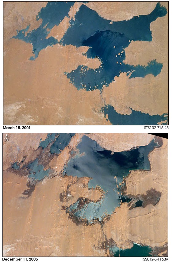
 Fig.2 The "NASA Earth Observatory" allows to see the evolution from 2001 to 2005, of the western Toshka Lakes. In the upper image, we have a record of the lakes as soon as they formed. But in 2005, the water level was strongly reduced.  

Let us see what happened by means of the NASA satellite imagery. The "NASA Earth  Observatory" allow us to see the evolution of the western Toshka Lakes (see Fig.2). In the upper image, we have a figure of the lakes as soon as they formed, 2001. But in 2005, the water level was strongly reduced. In Fig.3, the "NASA Earth Observatory" dated 2005 is compared with an image that we can obtain (on date July 21, 2011) from Google Maps. It is not possible for the author to tell when the Google image had been recorded. But, surely it is more recent, because we see a further reduction of the surfaces of the lakes.


 Fig.3 The "NASA Earth Observatory" of the western Toshka Lakes in 2005 (upper panel) is compared with an image from Google Maps (downloaded July 21, 2011). It is not possible for the  author to tell when the image of the lower panel had been recorded. But, surely it is more recent. We can see a further reduction of water in the lakes. 

Let us note that reference [4] is dated 2007. But what is the current situation of the lakes?
Let us try to answer using NASA images again, and in particular, those of the easternmost  Toshka Lake. In 2005, it was as shown in upper panel of Fig.4, as provided by the "Gateway to Astronaut Photography of Earth". The original image has been enhanced and rotated to compare it with that provided the Google Maps, displayed in the lower panel of Fig.4. As told for Fig.3, it is not possible for me to date the Google image; surely after 2005, because comparing the images, we note that the surface of the lake had shrunk.

 
Fig.4 The easternmost Toshka Lake in 2005, as provided by the "Gateway to Astronaut Photography of Earth", is shown in the upper panel. The original image has been enhanced and rotated to compare it with that provided (downloaded July 21, 2011) by the Google Maps, displayed in the lower panel.  Note that, it is not possible for me to date the Google image. I can only tell thta it is surely after 2005, because comparing the  images, we note that the surface of the lake had shrunk.    

But the "Gateway to Astronaut Photography of Earth" has a set of images of March 31, 2011,  quite recent then, that allowed me to create a composite map of the current aspect of the lake. The  map is proposed in Fig.5. This map had been rotated and enhanced as discussed in Ref. 5 (the image processing proposed in [5] has interesting applications in archaeology, see [6]). The processed images have so many details that we can use them to see the evolution of the lake. This is proposed in Fig.6, where we see a part of the lake, as it evolved from 2005 to March 31, 2011. In this figure we pass from the image dated 2005, to that of 2011, through that from Google Maps, of unknown date. This part of the easternmost lake was large in 2005, shrinking between 2005 and 2011, and reduced to one half the original in 2011, as it can be seen in Figure 7, where the superposition of the two NASA images, of 2005 and 2011, is proposed. We see the surface of the lake strongly decreased.

 
Fig.5 A set of images from the "Gateway to Astronaut Photography of Earth" dated, March 31, 2011, allows to create a composite map of the current aspect of the easternmost lake. This map had been rotated and enhanced as discussed in Ref. 5. The processed image has so many details useful for a comparison with the images in Fig.4.


Fig.6. From the image by the "Gateway to Astronaut Photography of Earth" dated 2005 (up-left), to that of March 31, 2011 (down-right), passing through that from Google Maps (up-right/down-left). The two images labelled with a question mark, are the same. The question mark means that the year when it was recorded is unknown to the author. We have the evolution of a part of the easternmost lake that was large in 2005 shrinking between 2005 and 2011, and reduced to one half the original part in 2011. The surface of the lake has dramatically decreased.  


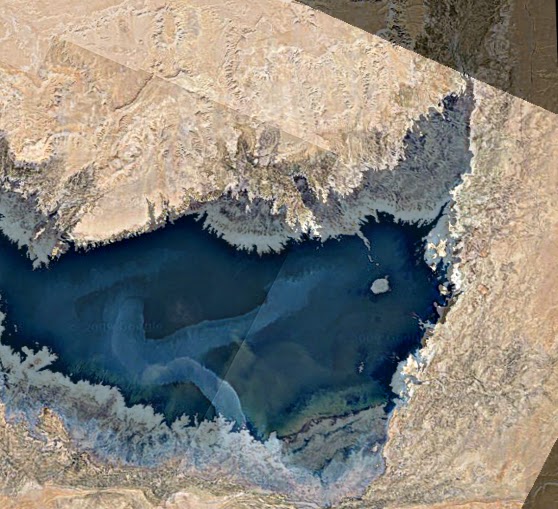
Fig.7. Superposition of the two NASA images, of 2005 and 2011, of Fig.6, proposed to help the reader in the comparison. 


Let me continue with a little bit of history. Egypt had already lived a similar situation, but on a  longer period and more than two thousand years ago. In Egypt there are several lakes; one is the Lake Moeris, an ancient saltwater lake in the northwest of the Faiyum Oasis. During the prehistory, the lake had freshwaters due to the high flood of Nile. From the XII Dynasty, in 2300 BC, the natural waterway from the river to the lake was widened and deepened to make a canal which is now known as the Bahr Yussef, "the waterway of Joseph" [7]. This canal served for the purpose to control the flooding of the river and help in irrigating the surrounding area. Moreover, the kings of the twelfth dynasty used the water of the natural lake of Faiyum in the dry periods. In fact these kings transformed the lake into a huge water reservoir, giving the impression that the lake was an artificial excavation, as reported by Pliny the Elder. He is writing, when discussing
the pyramids in his book [8], that two of them are “in the place where Lake Mœris was  excavated, an immense artificial piece of water, cited by the Egyptians among their wondrous and memorable works“ [8]. As the surrounding area changed, since the local branch of the Nile shrank, from about 230 BC, the Bahr Yussef became neglected and Lake Moeris began to dry up, creating a depression in the modern province of Faiyum [7].
As the history is showing, it is undoubtedly necessary for the Toshka Lakes what the researches  in Ref.4 are recommending, that is, to undertake measures to preserve these water resources and avoid the problem of the salinity of soil when the lakes dry up. Perhaps, it is too late.


References
1. Toshka Lakes, Wikipedia, http://en.wikipedia.org/wiki/Toshka_Lakes
2. In fact, it was with the Mercury missions in the early 1960s, that astronauts began to take  pictures of the Earth. The NASA, through its "Gateway to Astronaut Photography of Earth", provides a database with locations, supporting data, and digital images. The images are processed from those coming down from the International Space Station, http://eol.jsc.nasa.gov/. The "NASA Earth Observatory", created in 1999, has the same task. This is considered the principal source of satellite imagery and other scientific information on climate and environment, among the services provided by NASA, for the general public, http://en.wikipedia.org/wiki/NASA_Earth_Observatory, http://earthobservatory.nasa.gov/IOTD/view.php?id=1008
3. Gamal M. El-Shabrawy and Henri J. Dumont, The Toshka Lakes, in, The Nile, Monographiae  Biologicae, 2009, Volume 89, III, 157-162.
4. M. El Bastawesy, S. Arafat and F. Khalaf, Estimation of water loss from Toshka Lakes using  remote sensing and GIS, 10th AGILE International Conference on Geographic Information Science 2007, Aalborg University, Denmark, pp.1-9.
5. Anelia Carolina Sparavigna, Enhancing the Google imagery using a wavelet filter, 8 Sep 2010,  Geophysics (physics.geo-ph); Earth and Planetary Astrophysics (astro-ph.EP), arxiv:1009.1590
6. Amelia Carolina Sparavigna, The satellite archaeological survey of Egypt, 31 May 2011, Geophysics (physics.geo-ph), arXiv:1105.6315
7. http://en.wikipedia.org/wiki/Lake_Moeris
8. Pliny, The Natural History, Translated by John Bostock and H.T. Riley, Henry G. Bohm,
London, 1857

Tuesday, July 26, 2011

The decreasing level of Toshka Lakes seen from space

The decreasing level of Toshka Lakes seen from space
by Amelia Carolina Sparavigna, Dipartimento di Fisica,
Politecnico di Torino, Torino, Italy
Abstract

Toshka Lakes are lakes recently formed in the Sahara Desert of Egypt, by the water of the Nile, conveyed from the Nasser Lake through a canal in the Toshka Depression. From space, astronauts noticed the growing of a first lake, the easternmost one, in 1998. Then additional lakes  grew in succession due west, the westernmost one between 2000 and 2001. In fact, sources of  precious information on Toshka Lakes are the pictures takes by the crews of space missions and  the satellite imagery. They show that, from 2006, the lakes started shrinking. A set of recent  images displays that the surface of the easternmost lake is strongly reduced.
More
http://arxiv.org/abs/1107.4430

The easternmost of the Toshka Lakes in 2005 (NASA imagery)

 
The same lake in 2011 (NASA imagery, March 31, 2011)


Superposition of the two images. Note the strong decreasing of the surface of the lake. 

Read the detailed discussion at Toshka Lakes  on this blog.


Thursday, July 21, 2011

Shoemaker Impact Structure

"The Shoemaker (formerly Teague) Impact Structure—located in Western Australia in a drainage basin south of the Waldburg Range—presents an other-worldly appearance in this astronaut photograph. The Shoemaker impact site is approximately 30 kilometers (19 miles) in diameter and clearly defined by concentric ring structures formed in sedimentary rocks (brown to dark brown, image center). The rocks were deformed by the impact event approximately 1.63 billion years ago (as reported by the Earth Impact Database). Other age-dating analyses of granitic rocks at the core of the structure call this age into question (Pirajno et al. 2003)."
http://eol.jsc.nasa.gov/EarthObservatory/Shoemaker_Impact_Structure.htm
"Beginning with the Mercury missions in the early 1960s, astronauts have taken photographs of the Earth. Our database tracks the locations, supporting data, and digital images for these photographs. We process images coming down from the International Space Station on a daily basis and add them to the 1,101,059 views of the Earth already made accessible on our website."

Friday, July 15, 2011

Desert kites and stone circles

Stone structures in the Syrian Desert - by Amelia Carolina Sparavigna, Dipartimento di Fisica,
Politecnico di Torino, Torino, Italy

Paper published on ARCHAEOGATE http://www.archaeogate.org/
Here I am reporting a part of my paper, with some figures. To read the complete article, visit the link

An arid land, known as the Syrian Desert, is covering a large part of the Middle East, extending from the northern Arabian Peninsula to the eastern Jordan, southern Syria, and western Iraq. In the past, this harsh environment characterized by huge lava fields, the "harraat" [1], was considered as a formidable barrier between Levant and Mesopotamia. This desert possesses two volcanic regions: one is the Jabal al-Druze in As-Suwayda Governorate, the other field is the Harrat Ash Shaam in South Syria, south-east of Damascus [2,3]. When we observe these huge harraat from space, using for instance the Google Maps, we discover that they are crossed by several stone structures, known as "desert kites", which were the Neolithic stone traps for the game. These structures were firstly observed by the pilots of the Royal Air Force in the 1920s, flying over the desert. The pilots named them "kites", because these lines reminded of kites used by children to play [4]. Beside the kites, many stone circles are visible too, as many Stonehenge sites dispersed in the desert landscape. Probably, this harsh environment was friendlier and then quite populated in ancient times.

We usually imagine our ancestors, before they settle down, as people simply hunting and gathering for food, but this is not true. The "desert kites" are the remains of an ancient hunting technique based on stone-walled traps, the construction of which surely involved several people for long times. The desert kites were used to push large herds of animals into some enclosures, or, in the worse case, to fall off from steep cliff edges [4]. The simplest structure of a desert kite has a triangular shape, consisting of two long, low walls built of stones and arranged in a V-shape, like a funnel, ending as a corral. Hunters pushed the game between the walls, trapping then the animals into the end of the structure. It is usually considered that the animals were there slaughtered "en masse" [4-7]. The fauna remains found in these sites are including gazelles, Arabian oryxes and other species that are now rare or driven to extinction in the Levant [4]. A research at the Mesopotamian site of Tell Kuran, found what seems to be a deposit from a mass kill. According to [6], it was the overuse of desert kites a possible cause of extinction of several species.


Fig.1. The wonderful structure of a “desert kite”(Jordan), as it can be observed with Google Maps.


Fig.2: A landscape with desert kites and other stone structures (Jordan). This is an image adapted from the Google Maps. The visibility of marked areas has been adjusted with image processing software.


Fig.3: Desert kites. The images have been adapted from the Google Maps. The visibility of the stone strctures has been adjusted with image processing software.

Typically, a desert kite possesses two, three or more small circular enclosures on the edge of its corral (in Fig.1 a wonderful structure as it can be observed with Google Maps, other examples in Fig.2 and 3). Some ancient rock art images show these hunting traps [8], depicting the role of the 'walls' of the kites. ...
....
As we discussed in the paper on Arabia [11], an interesting fact is necessary to note [8]. In the Khaybar area, Arabia, there are some remains of Neolithic villages very close to the hunting desert kites. Linking the "desert kites" with "human villages" could be a mistake, because wild animals are avoiding places where people live. Since the Khaybar area is full with ancient burial structures, sometimes placed inside the desert kites, a possible conclusion is that these burial mounds are more recent than the desert kites [8]. Because this conclusion is coming from the observation of satellite images, it seems that the satellites, and in particular the Google Maps, can help the archaeological researches providing a portrait of the human collective activities in the early stages of civilization.
Even the Syrian Desert is dispersed with circular stone structures and mounds, sometimes inside or near the desert kites (see Fig.2 for instance). On these earlier human settlements, news was announced last year that Robert Mason, archaeologist of the Royal Ontario Museum, discovered what we can define as a Syrian Stonehenge [12]. The site, near the Deir Mar Musa al-Habashi monastery, is composed by some tombs and stone circles. From the stone tools he found there, it's likely that the structure dates from the Middle East's Neolithic Period, roughly ranging from 8500 BC to 4300 BC. In Western Europe, the first structures built of stone date back approximately to 4500 BC. The Syrian site is then quite older than the European sites. Edward Banning of the University of Toronto says that more fieldwork is necessary because it is possible that the landscape that Robert Mason has identified could be an example, in the Neolithic period, of burial practices out of the settlement, that is, an off-site cemetery [12].
The report in [12] is continuing with a suggestion by Julian Siggers, of the Royal Ontario Museum. Remembering that agriculture spread from the Near East to Europe, he is proposing the possibility that the stone landscapes, that is the creation of stone circles, had travelled with agriculture. On the other hand, Banning is replying that stone structures are found throughout the world and that people in Western Europe could have developed the stone landscapes independently of the people in Middle East. According to Edward Banning, the site studied by Mason is not unique [12,13]. "Archaeologists have detected, via satellite photos, what appear to be cairns and stone circles in other areas, including the deserts of Jordan and Israel. However, he admits that most of these things have not received a lot of archaeological investigation."
....

References
1. In Arabic, the lava fields are the harraat, sing. harrah; before a name, harrat.
2. Jabal al-Druze Volcanic Field in Southern Syria – May 16th, 2010, http://www.eosnap.com/image-of-the-day/jabal-al-druze-volcanic-field-in-southern-syria-may-16th-2010/
3. Global Volcanic Program, Es-Safa, http://www.volcano.si.edu/world/volcano.cfm?vnum=0300-05-
4. Mysterious desert lines were animal traps, Larry O'Hanlon, Apr 20, 2010, http://news.discovery.com/history/desert-lines-hunting-tool-kites.html
5. Desert Kites, Ancient Hunting Technique Desert Kites, K. Kris Hirst, About.com Guide, http://archaeology.about.com/od/dathroughdeterms/qt/Desert-Kites.htm
6. Role of mass-kill hunting strategies in the extirpation of Persian gazelle (Gazella subgutturosa) in the northern Levant, Guy Bar-Oz, Melinda Zeder, Frank Hole, Proceedings of the National Academy of Sciences, Early Edition, May 3, 2011, vol. 108, no. 18, 7345-7350, doi:10.1073/pnas.1017647108,
7. Gazelles caught in ancient Syrian 'killing zones', Jonathan Amos, BBC News, 19 April 2011.
8. Khaybar Desert Kites, Vanja Janežic, alsahra.org/wp-content/uploads/2009/02/khaybar-desert-kites.pdf, see also http://www.megalithic.co.uk/article.php?sid=2146412866
9. The function of "Desert Kites" - Uniting or livestock husbandry? B. Rosen, A. Perevolotsky, Paléorient, Vol.24, Pag. 107-111, 1998.
10. The Desert "Kites" of the Badiyat Esh-Sham and North Arabia, A.V.G. Betts, S. Helms, Paléorient, Vol.13, Pag. 41-67, 1987.
11. Arabia: from craters to stone circles, Amelia Carolina Sparavigna, Archaeogate, 19-11-2010, and also, http://arxiv.org/abs/1011.2111
12. Syria's Stonehenge: Neolithic stone circles, alignments and possible tombs discovered, Owen Jarus, Monday, 1 March 2010, The Independent, http://www.independent.co.uk/life-style/history/syrias-stonehenge-neolithic-stone-circles-alignments-and-possible-tombs-discovered-1914047.html
13. A web-site, 27 March 2011, http://www.stonepages.com, published the news of a 11,000-year-old settlement unearthed in Syria. A Syrian-French archaeological mission unearthed a small village in the archaeological site of Tel Qarasa in the west of Swaida province dating back to around 11,000 years. The search conducted at the site over the last two years allowed the archaeologists to discover a tiny village of 8 round houses whose inhabitants depended on fishing and growing cereal crops and wild fruits for their living. The Syrian-French mission said the excavations have revealed 522 archaeological sites in al-Lajat region from the ancient historical periods of the 7th millennium BCE, among which was Tel Qarasa.
14. More images at https://sites.google.com/site/syriandesertsatelliteimagery/
15. According to Wikipedia, desert kites and stone circles can be considered as Petroforms.

Fig. 4: A stone circle in Syrian Desert. The images have been adapted from the Google Maps.

Fig. 5: Other stone circles in Syrian Desert. The images have been adapted from the Acme Mapper.

Fig. 6: Stone landscape in Syrian Desert. The images have been adapted from the Google Maps. Note the “dots” that are surrounding the circular complexes.

Thursday, June 30, 2011

Enborne crop circle

From Google Maps.

"A SHARP-eyed Newbury resident spotted this strange formation off the Enborne Road in Newbury while studying computer satellite images. Construction manager Rob Fox, of St John’s Road, was looking for an alternative route to work using on-line aerial maps when he spotted what appeared to be a crop circle outline in ploughed earth."
http://www.newburytoday.co.uk/News/Article.aspx?articleID=10089

Friday, June 10, 2011

The bent pyramid

Google Maps is an excellent service for archaeological survey. Let us look at the Bent Pyramid in Egypt.


After a processing by means of AstroFracTool and GIMP, we have


Or using the wavelets of Iris


Interesting for mapping sites! In my opinion, there are many other structures in these images which are connected to the pyramid (for instance, the one that seems a pool near the upper left corner), besides those listed in the following map.
This map is adapted from: 

Tuesday, June 7, 2011

The cradle of Egyptian pyramids

The cradle of pyramids in satellite images,  by Amelia Carolina Sparavigna, Dipartimento di Fisica, Politecnico di Torino, Torino, Italy
http://arxiv.org/abs/1106.0818

We propose the use of image processing to enhance the Google Maps of some archaeological areas of Egypt. In particular we analyse that place which is considered the cradle of pyramids, where it was announced the discovery of a new pyramid by means of an infrared remote sensing.

Saqqara and Dahshur are burial places of the ancient Egypt. Saqqara was the necropolis of Memphis, the ancient capital of the Lower Egypt. This place has many pyramids, including the well-known step pyramid of Djoser, and several mastabas. As told in Wikipedia, 16 Egyptian kings built pyramids there and the high officials added their tombs during the entire pharaonic period [1]. The necropolis remained an important complex for non-royal burials and cult ceremonies till the Roman times. Dahshur is another royal necropolis located in the desert on the west bank of the Nile [2]. The place is well-known for several pyramids, two of which are among the oldest and best preserved in Egypt. Therefore this site can be properly considered as the cradle of Egyptian pyramids [3]. Figure 1 shows the Djoser pyramid and the Great Enclosure at Saqqara. The two images have been obtained from Google Maps after an image processing with two programs, AstroFracTool, based on the calculus of the fractional gradient, and the wavelet filtering of Iris, as discussed in Ref.4. The reader can compare the images with the original Google Maps, using the coordinates given in the figure [5].
Recently the BBC announced the discovery in the area between Saqqara and Dashur, near the river Nile, of a new pyramid buried in the sand [6]. The pyramid has been observed by means of the infrared remote sensing. According to the images in Ref.7, it is located near the pyramid of Khendjer, discovered by Gustave Jequier in 1929, built as the tomb of king Khendjer, who ruled Egypt during the 13th Dynasty [8]. The pyramid currently lies in ruins, in part damaged during the excavations done by Jequier, and it is rising just one meter above the desert sand. The pyramid complex was enclosed by inner and outer walls. The inner wall was made of limestone, the outer wall was made of mud bricks. According to Wikipedia, the pyramid stood at about 37.35 meters high [8].
It is interesting to observe the structure of this pyramid from the space with Google Maps. After a processing by means of AstroFracTool and Gimp [4], we obtained the lower panel in Fig.2. According to Ref.[8], the ruins are rising only a few meters above the grounds; the Google Maps, however, after a suitable processing are displaying all the details of the Khendjer complex.
As BBC announced, Sarah Parcak, of the University of Alabama, used some data from NASA infrared equipped satellites to survey the Egypt. Waiting for a more detailed report on her researches and on the methods the team used, let us observe the images that some Web sites are publishing, in particular that of the Khendjer complex (for the author it is impossible to tell whether the images are the original infrared ones or not). According to [7], it is in this complex that there is one of the discovered pyramids. The site is shown in Fig.3, where the upper panel is displaying as it appears in Google Maps, and the lower panel shows it after processing by means of AstroFracTool. It seems a ghost image having the same features of the complex outlines in Fig.2.
According to the Egypt's Minister of State for Antiquities Affairs, Zahi Hawass, the new technologies are able to locate the remains beneath the sand [9], but it is necessary to identify them with archaeological researches on the spot. Of course, a research on the area will be able to tell the name of the king buried in the site.
As discussed in Ref.10, there are several remote sensing techniques that can be useful in archaeology. For what concerns the Google Maps, let me remark its use in the study of the Merowe Dam and the paleochannels of the Nile where we compared the images from SIR-C/X-SAR imaging radar system, with those from Google [11].
It is my opinion that the image processing of Google Maps can be used for an archaeological survey of Egypt (see for instance, some examples on the satellite images of Amarna, [11]), besides of course, all the satellite methods used for geophysical researches. For what concerns the proposed processing of Google Maps, it is important to note the following fact: it is during the processing activity, when the user is changing parameters and details appear in the picture, that it is easier to recognize them. The information is already in the image: it is only enough to take it out.

References
1. http://en.wikipedia.org/wiki/Saqqara
2. http://en.wikipedia.org/wiki/Dahshur
3. From A to Z, Dahshur, http://www.ancient-egypt.org/index.html
4. Enhancing the Google imagery using a wavelet filter, A.C. Sparavigna, http://arxiv.org/abs/1009.1590
5. See images at the site https://sites.google.com/site/saqqaradahshursatellite/
6. Egyptian pyramids found by infra-red satellite images, F. Cronin, BBC New, 24 May 2011,
http://www.bbc.co.uk/news/world-13522957
7. http://www.dailymail.co.uk/sciencetech/article-1390667/Seventeen-lost-pyramids-thousands-buried-Egyptian-settlements-pinpointed-infrared-satellite-images.html?ito=feeds-newsxml, and also http://www.allvoices.com/contributed-news/9202577-egyptian-pyramids-found-by-infrared-satellite-images
8. http://en.wikipedia.org/wiki/Pyramid_of_Khendjer
9. News broadcast by BBC is inaccurate, says Hawass, N. El-Aref, Ahramonline, 26 May 2011, http://english.ahram.org.eg/
10. The satellite archaeological survey of Egypt, A.C. Sparavigna, http://arxiv.org/abs/1105.6315
11. The Merowe Dam on the Nile, A.C. Sparavigna, http://www.archaeogate.org/, and, Merowe Dam and the inundation of paleochannels of the Nile, A.C. Sparavigna, http://arxiv.org/abs/arXiv:1011.4911
12. Some image processing on Amarna,
https://sites.google.com/site/amarnasatelliteimagery/


 Fig.1: The Djoser pyramid and the Great Enclosure at Saqqara, Egypt. The images have been obtained from Google Maps after a processing by means of AstroFracTool and Gimp, in the upper panel, and Iris wavelets, in the lower panel. For a discussion of the processing see Ref.4. The figure is giving the coordinates for a comparison with the original Google Maps’ image [5].

 Fig.2 The Khendjer complex as seen from the space, with Google Maps. After a processing by means of AstroFracTool and Gimp [4], we have the lower panel. According to Ref.[8], the ruins are rising only a few meters above the grounds; Google Maps, however, after a suitable processing are displaying all the details.


Fig.3. According to [7], it is in the Khendjer complex that there is one of the discovered pyramids. The upper panel is showing as it appears in Google Maps, the lower panel shows it after processing by means of AstroFracTool. It seems a ghost image having the same features of the complex outlines in Fig.2.

Wednesday, June 1, 2011

The satellite archaeological survey of Egypt

The satellite archaeological survey of Egypt
by Amelia Carolina Sparavigna

A recent announcement from BBC of 17 new pyramids discovered in Egypt arouses the interest on the archaeology aided by satellites imagery [1]. These pyramids, as many other ancient remains in Egypt, are under the sand of the desert. They were discovered by means of a remote sensing with infrared sensors. In fact, the archaeological surveys, usually performed by means of airplanes, are necessary to observing the sites from above and gain a better view of the landforms. In some cases, the survey of a region ends with the discovery of new archaeological sites or with the precise location of an ancient lost town [2].
Satellites give different opportunities, according to their sensorial equipment. BBC announced that Sarah Parcak, of the University of Alabama, used some data from NASA infrared equipped satellites to survey the Egypt. Waiting for a more detailed report on her researches and on the methods the team used, we can just tell that the infrared inspection is based on collecting the radiances in various wavelength bands, in the infrared range of the electromagnetic spectrum. The resulting profiles depend on the methods used to obtain the surface data from radiances. To have a good detection, the surface must be free from clouds.
The Egypt's Minister of State for Antiquities Affairs, Zahi Hawass, seems to be quite interested to the new technologies, but, as he told Ahram Online, the satellite infrared images are only able to locate the remains beneath the sand [3]. It is then necessary, according to Hawass, to identify them with archaeological researches on the spot. From the news on the Web it is not clear how many sites have been analyzed by the team of the University of Alabama. It seems that the amount of data collected by the researchers is huge.
Besides the analysis with infrared imagery, let us consider that there are other remote sensing techniques that can be useful in archaeology: among them we have the LIDAR system, which is, as we discussed in [4], able to see under the canopy of the forests, and the SIR-C/X-SAR imaging radar system, which has waves that can penetrate the clouds, and, under certain conditions, vegetation, ice and dry sand [5]. Of course, these facilities are not freely available and needs financial supports.
We could then ask ourselves if a free satellite service, such as Google Maps, can help in some archaeological researches in Egypt. It is my opinion that the answer is positive. In studying the Merowe Dam and the paleochannels of the Nile we could compare the images from SIR-C/X-SAR imaging radar system, with those of the Google Maps [6]. After a suitable image processing with some freely downloadable programs (GIMP, IRIS, AstroFracTool,[7]), the Google Maps revealed astonishing details of the network of old buried channels of Nile in the Nubian region. The same for the "raised fields" near the Titicaca Lake in Peru: the processing of the images clearly displayed the network of these ancient earthworks and canals [8]. Many of these structures are probably buries under some sediments of the lake.
Let us then try to apply the image processing to the Google Maps of those areas in Egypt, where according to the press, the infrared satellite imagery is giving good results. We see that one of these investigated areas is that of Tanis, a town of the ancient Egypt. In Fig.1, it is shown what we can have after processing the image from Google Maps. The upper part of the figure is obtained using the GIMP image- processing program, to adjust brightness and contrast. The lower part is gained after a processing with the wavelet filtering of Iris. These images seem to contain quite clear information on the buried town too.
Another example is the site where there are buried pyramids, according to the press [9,10]. The site is at Saqqara: Figure 2 shows the area as can be seen after a processing of Google Maps. The reader is invited to compare these images with those published on the Web, copyrighted BBC. I guess that after comparison, the reader can draw some positive conclusions about Google Maps and its use for an archaeological survey of Egypt. I am proposing another example of the use of image processing in Fig.3. This is the Great Temple at Amarna, buried under the sand (more images at [11]).
As Zahi Hawass is telling, it is necessary to understand whether some “anomalies” revealed by the satellite remote sensing are archaeological remains or not. This means that archaeology can only receive benefits for geophysics researches and the related use of remote sensing.

References.
1. Egyptian pyramids found by infra-red satellite images, F. Cronin, BBC New, 24 May 2011, http://www.bbc.co.uk/news/world-13522957
2. Documentation of the Abandoned Town La Ciudad Perdida in Peru Combining VHR Satellite Data and Terrestrial Measurement, K. Pavelka, M. Bukovinsky, J. Svatuskova, Remote Sensing for Science, Education and Natural and Cultural Heritage,  Rainer Reuter Ed., EARSeL, 2010.
3. News broadcast by BBC is inaccurate, says Hawass, N. El-Aref, Ahramonline, 26 May 2011, http://english.ahram.org.eg/
4. Lines under the forest, A.C. Sparavigna, http://www.archaeogate.org/, and http://arxiv.org/abs/1105.5277.
5. SIR-C X-SAR Earth-Imaging Radar for NASA's Mission to Planet Earth, Infopage.
6. The Merowe Dam on the Nile, A.C. Sparavigna, http://www.archaeogate.org/, and, Merowe Dam and the inundation of paleochannels of the Nile, A.C. Sparavigna, http://arxiv.org/abs/arXiv:1011.4911.
7. Enhancing the Google imagery using a wavelet filter, A.C. Sparavigna, http://arxiv.org/abs/1009.1590.
8. The geoglyphs of Titicaca, A.C. Sparavigna, http://www.archaeogate.org/ and Symbolic landforms created by ancient earthworks near Lake Titicaca, A.C. Sparavigna, http://arxiv.org/abs/1009.2231.
9. http://www.dailymail.co.uk/sciencetech/article-1390667/Seventeen-lost-pyramids-thousands-buried-Egyptian-settlements-pinpointed-infrared-satellite-images.html?ito=feeds-newsxml, and also
http://www.allvoices.com/contributed-news/9202577-egyptian-pyramids-found-by-infrared-satellite-images
10. In my opinion, the published images at [9] are not the real infrared images of the Alabama University team, but this is what is published on the web.
11. Some image processing on Amarna, https://sites.google.com/site/amarnasatelliteimagery/


Fig.1: Tanis as can be observed after processing an image from Google Maps. In the upper part, brightness and contrast had been adjusted with GIMP. The lower image was obtained with a wavelet filtering with Iris. It seems that the image is giving quite good details too.


Fig.2. This is the Saqqara area where there is a buried pyramid. The image has been obtained after processing a Google Maps image. According to Refs.[9], in this area there one of the buried pyramid announced by BBC [1]. (SEE PLEASE THE NOTE AT THE END OF THIS POST)


Fig.3: The Great Temple in Amarna, as can be seen after processing a Google Maps image.


---------------------

NOTE 11 November 2018

For what concerns the Figure 2, here I would like to show you also - in the blue insert of the following image - that published by BBC of the pyramid.


Here the insert is used  just for information, to show in an image of Google Maps, after enhancing the contrast, the place where Sarah Parcak told she has evidenced a pyramid. I beg BBC pardon for the use of the insert, but I have seen today, at the following  link
 that my image was used for a hoax of a human settlement under the ice. Let me thank Maarten Schenk for having evidenced this fact.  I am quite upset by the use of an image of mine in this hoax.
I repeat, I am discussing the work by Sarah Parcak and the use of satellites for the archaeology in Egypt. Let me stress that the IMAGE is an image from Egypt, and the article of BBC was on Egypt. Nothing to do with ICE, only SAND!


Amarna

The following images are showing a great temple in Amarna, the city of Akhetaten.
The images have been obtained applying an image processing to Google Maps. 


The image processing is done by means of  GIMPIRIS and AstroFracTool.

Tanis - a detail


A detail of Tanis (from Google Maps, after processing).
For more details see

Tuesday, May 31, 2011

The Hindu : Sci-Tech / Internet : New crater in Sudan discovered using Google Maps


"Software scientists have discovered a 10 kilometre wide crater like structure in the Bayuda Desert of Sudan using Google Maps...
Amelia Sparavigna from the Politecnico di Torino in Italy said she got the idea from Italian researcher Vincenzo de Micheles who identified an impact crater in the remote desert of southern Egypt by 2008 using Google Earth. Located between the fourth and sixth cataract, the area is characterised by basaltic rocks from ancient volcanoes. Sparavigna noticed “a non-perfect round shape about 40 kilometres in diameter” on the eastern bank of river Nile. She then processed the original Google Maps satellite image with an astronomical image-processing program. “Aerial photography is expensive and satellite imagery doesn’t always have good enough resolution. But in this case they have been able to generate some interesting images which have been further enhanced,” ABC Science quoted Professor David Cohen, a geologist, as saying."

Monday, May 30, 2011

Tanis map


This image is showing the ruins of the ancient city of Tanis (an archeological site in Egypt, well-known from the Indiana Jones' movie). The image has been obtained from the original image from Google Maps, with a certain image processing. The following is the original image from Google. 


You can use GIMP and IRIS program to enhance the details, and obtain the following image. 


Or you can use AstroFracTool and Gimp


For more details see

Thursday, February 24, 2011

La Medusa di Wayland's Smithy

Un crop circle del 2009, che si vede con Google Maps. "Formazione anomala, e spettacolare. È stata riportata da tutti i media internazionali in quanto dotata di una rara quanto unica energia espressiva."


Wayland's Smithy is a Neolithic long barrow and chamber tomb site located near the Uffington White Horse and Uffington Castle, at Ashburyin the English county of Oxfordshire (historically in Berkshire).

Thursday, January 27, 2011

"Eye" of Sahara

During a survey by means of Google Maps of the desert near the Nile, I have seen this structure, which seems an eye on the sand.


It is small when compared to the huge Richat structure in Mauritania.

Richat Structure

The Richat Structure is a huge circular feature in the Sahara desert of Mauritania near Ouadane. It has attracted attention since the earliest space missions because it forms an eye. The structure has a diameter of approx 50 kilometres. It was initially supposed a meteorite impact structure.


Image obtained by Google Maps

Wednesday, January 26, 2011

Woodhenge

Woodhenge is a Neolithic henge and timber circle monument located in the Stonehenge World Heritage Site in Wiltshire, England. Woodhenge was identified in 1925 after an aerial archaeology survey by Alexander Keiller and OGS Crawford. Crawford credits the discovery to an aerial photograph.
Most of the 168 post holes held wooden posts, although Cunnington found evidence that a pair of standing stones may have been placed between the second and third post hole rings. The positions of the postholes are currently marked with modern concrete posts which are a simple and informative method of displaying the site. Further comparisons with Stonehenge were quickly noticed by Cunnington; both have entrances oriented approximately on the midsummer sunrise. 
more wiki