
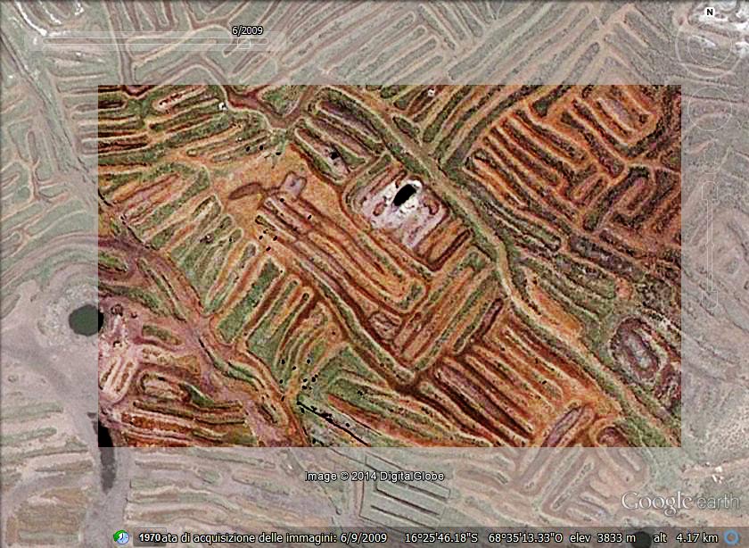
The image, obtained from Google Maps, shows the network of earthworks separated by canals - near the Titicaca Lake. This is an ancient agricultural technique used by Andean people starting from the first millennium BC.
More on Titicaca
arXiv:1009.4602 [pdf] Geoglyphs of Titicaca as an ancient example of graphic design,
Amelia Carolina Sparavigna
arXiv:1009.2231 [pdf] Symbolic landforms created by ancient earthworks near Lake Titicaca, Amelia Carolina Sparavigna
A.C. Sparavigna (2012)
Image Processing for the Enhancement of Satellite Imagery. In: Image Processing: Methods, Applications and Challenges / Vítor Hugo Carvalho. Nova Science Publishers, Inc. (USA), pp. 149-161. ISBN 9781620818442
Image Processing for the Enhancement of Satellite Imagery. In: Image Processing: Methods, Applications and Challenges / Vítor Hugo Carvalho. Nova Science Publishers, Inc. (USA), pp. 149-161. ISBN 9781620818442
| A.C. Sparavigna, R. Marazzato (2011) Using Geographic Information Systems to Increment the Knowledge of Cultural Landscapes. In: Smart Tech & Smart Innovation, La strada per costruire il futuro, Torino, 15-17 Novembre 2011. | ![[img]](https://lh3.googleusercontent.com/blogger_img_proxy/AEn0k_uJq8ndOmL2AW6UO7sZEhncE9LCtr7B9klGbht__q_xiAYnLJMjm3LoHMWBna_14JRN5owdlFDYSG213OSE_6K-YrnhQXoAI5NfW6hWqbACESYTWgHRufYy0h2DN9XaRVrbIpqRSDgSI-B5CADurSyontu8IAqYuSvEatD8DXh7Njcy55taXLXSxdZR7_WSbdcDJMugjJO9Pjrbe5vrDhYzZhTC2_9vwUgNEl9cVd7SY10Eqmy2vD0W=s0-d) ![[img]](https://lh3.googleusercontent.com/blogger_img_proxy/AEn0k_vLHcpUAbYwbZGwQ6idTJGdo83_zy7JsJm3g0PN8VsXgiLE58NuljpREy2OA16aSSVOUInkqrtZZ5aKfRZdi2itV3P5S9Gfkrjl0Zr-SjuIzjNyKk2zxiErHcsQk8RtDo4v1JvNXdBL8W5ZSVUiKNPHvWg04yyo0a5E_fHfutl_8b5LKg=s0-d) | |
|
![[img]](https://lh3.googleusercontent.com/blogger_img_proxy/AEn0k_tTeQ3NS0SWWgDLVN_cphjMobWNhXc0_3DGyOn_mM_yNrR_twxaLltM0gbxxR6bPzsWTolm8wYFZ3JmrH0nTO2reLkDnkovn7Bir7qhIHa52UOgsfvC4_JVztPTKZF6DURuvd3YVJWMNTicZvpkwgjNjy-SYANo8B8T1ZxZZ5__E_ZEzvJc2iGsgjPFJmY3pFNi0fD1h3oVOKlL_v-VYhFksXkuBd3765zIytBO9CmmL76eGlmQwOU9BNe0utV8H18=s0-d)
![[img]](https://lh3.googleusercontent.com/blogger_img_proxy/AEn0k_uLDeJbrHMijATFdyJHZNVcH7ssMPgW572kRdFoBqwGQhoRt8ZEie_1YhgFMCL63894uhilAt82wD5eujFoDd6loOUo_Y0lRj93kX0-lWPv0aDMZ1s6HQqMihH6N-btqewjOjPHJRLnml3fvSKep0sj39u1Tiv0gBEPm590qYwM2BV43XIABPkWAZWrfG0dyBNRckO-0uggL8TI8lJ2qWyaoObVBNhNJW0alZ03rj2CLu39c4T_fO-CGFHg_XqoC-6Y2TCqOl4GDvc8-56nI5TwZBBkrkOQTYY=s0-d)

